Trail Walking Montillières-sur-Orne - La vallée de l'Orne - Thury Harcourt - Photo

La vallée de l'Orne - Thury Harcourt

 tracegps
tracegps

User

© OpenStreetMap contributors
Length
Length
17.1 km
Max alt
Max alt
135 m
Uphill gradient
Uphill gradient
421 m
Km-Effort
Km-Effort  
23 km
Min alt
Min alt
18 m
Downhill gradient
Downhill gradient
425 m
Boucle
Boucle
Yes
Creation date :
2014-12-10 00:00:00.0
Updated on :
2014-12-10 00:00:00.0

(1 Reviews)

Walking
Walking
4h15
Difficulty : Difficult

Scan this QR Code to open this trail in the SityTrail application

FREE GPS app for hiking

Logo SityTrail SityTrail

IGN / Geographical institutes

Download SityTrail from the App Store Download SityTrail from Google Play

Logo SityTrail SityTrail World

The world is yours!

Download SityTrail from the App Store Download SityTrail from Google Play Download SityTrail on Huawei AppGallery

About

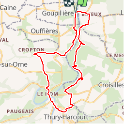
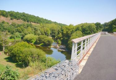
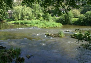
Trail Walking of 17.1 km to be discovered at Normandy, Calvados, Montillières-sur-Orne. This trail is proposed by tracegps.

Description

Au sud de Caen, l’Orne est très pittoresque. Ce circuit vous invite à en découvrir les deux rives au Nord de Thury Harcourt.

Elevation profile

Photos

Positioning

Country:
France
Region :
Normandy
Department/Province :
Calvados
Municipality :
Montillières-sur-Orne
Location:
Goupillières
Start:(UTM)
685106 ; 5434217 (30U) N.

Comments

Please log in to post a review or rate the element


du plan d'eau de thury au dessus du camping impossible le sentier est en super pente et non entretenu ...


Trails nearby

Trail Mountain bike Montillières-sur-Orne - curcy trois monts - Photo
Mountain bike
albers

Mountain bike

Medium
(1)
Montillières-sur-Orne, Normandy, Calvados, France
28 km | 35 km-effort
1h 59min
Yes
Trail On foot Le Hom - La Vallée de l'Orne - Photo
On foot
PRO

On foot

Medium
Le Hom, Normandy, Calvados, France
17.1 km | 23 km-effort
5h 10min
Yes
Trail On foot Espins - D'Espins au Moulin du traspy - Photo
On foot
PRO

On foot

Easy
Espins, Normandy, Calvados, France
6.9 km | 9 km-effort
2h 3min
Yes
Trail Walking Maizet - COUDRAY 20 KM - Photo
Walking
UDGI54

Walking

Difficult
(2)
Maizet, Normandy, Calvados, France
19.8 km | 25 km-effort
5h 26min
Yes
Trail Walking Le Hom - le pont Hom (boucle) - Photo
Walking
jlesacher

Walking

Medium
(1)
Le Hom, Normandy, Calvados, France
12.1 km | 16 km-effort
2h 45min
Yes
Trail Road bike Montillières-sur-Orne - Voie verte suisse normande - Photo
Road bike
yves62410

Road bike

Easy
Montillières-sur-Orne, Normandy, Calvados, France
47 km | 53 km-effort
4h 14min
Yes
Trail On foot Grimbosq - Moulin de Pray et Pont de Brie - Photo
On foot
PRO

On foot

Easy
Grimbosq, Normandy, Calvados, France
4.3 km | 4.9 km-effort
1h 6min
No
Trail Walking Mutrécy - Mutrecy - Photo
Walking
Eve - Line

Walking

Medium
Mutrécy, Normandy, Calvados, France
25 km | 29 km-effort
5h 6min
Yes
Trail Mountain bike Mutrécy - Rando VTT Mutrecy 2010 45klm - Photo
Mountain bike
tracegps

Mountain bike

Difficult
Mutrécy, Normandy, Calvados, France
43 km | 55 km-effort
3h 15min
Yes


Close
My subscriptions