Trail Walking Saulces-Monclin - Au sud de Saulces-Monclin  - Photo

Au sud de Saulces-Monclin

 tracegps
tracegps

User

© OpenStreetMap contributors
Length
Length
10.5 km
Max alt
Max alt
131 m
Uphill gradient
Uphill gradient
111 m
Km-Effort
Km-Effort  
12 km
Min alt
Min alt
89 m
Downhill gradient
Downhill gradient
111 m
Boucle
Boucle
Yes
Creation date :
2014-12-10 00:00:00.0
Updated on :
2014-12-10 00:00:00.0

(1 Reviews)

Walking
Walking
2h45
Difficulty : Medium

Scan this QR Code to open this trail in the SityTrail application

FREE GPS app for hiking

Logo SityTrail SityTrail

IGN / Geographical institutes

Download SityTrail from the App Store Download SityTrail from Google Play

Logo SityTrail SityTrail World

The world is yours!

Download SityTrail from the App Store Download SityTrail from Google Play Download SityTrail on Huawei AppGallery

About

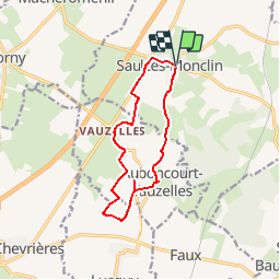
Trail Walking of 10.5 km to be discovered at Grand Est, Ardennes, Saulces-Monclin. This trail is proposed by tracegps.

Description

Départ de la nouvelle église de Saulces-Monclin, direction d'Auboncourt joli village sur une petite crête avec un lavoir. Un petit détour pour voir l'étrange monument puis retour en zig zag sur Vauzelles (lavoir grange typique de la région) retour à Saulces où il y a une très jolie ancienne église.

Elevation profile

Photos

Positioning

Country:
France
Region :
Grand Est
Department/Province :
Ardennes
Municipality :
Saulces-Monclin
Location:
Unknown
Start:(UTM)
608219 ; 5492565 (31U) N.

Comments

Please log in to post a review or rate the element


Trails nearby

Trail Car Saulces-Monclin - Venet_150423 - Photo
Car
d.rognon

Car

Easy
Saulces-Monclin, Grand Est, Ardennes, France
194 km | 230 km-effort
2h 12min
No
Trail Walking Vaux-Montreuil - vaux monyreul - Photo
Walking
gilbertwarin08

Walking

Medium
Vaux-Montreuil, Grand Est, Ardennes, France
10.7 km | 13.3 km-effort
2h 30min
Yes


Close
My subscriptions