


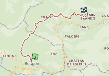
Rougon - Villars Brandis

soca
User

Length
12.7 km

Max alt
1249 m

Uphill gradient
565 m
Km-Effort
20 km

Min alt
850 m

Downhill gradient
516 m
Boucle
No
Creation date :
2022-04-09 12:45:27.466
Updated on :
2022-04-09 12:53:08.963
4h30
Difficulty : Difficult

FREE GPS app for hiking
 SityTrail
IGN / Geographical institutes
SityTrail Plus
The world is yours!
About
Trail Walking of 12.7 km to be discovered at Provence-Alpes-Côte d'Azur, Alpes-de-Haute-Provence, Rougon. This trail is proposed by soca.
Description
Rougon - GR4. GRE7 - Chapouplan Chasteuil - le vieux Chasteuil sous les Cadiéres de Brandis - St Jean - Villars Brandis
Positioning
Country:
France
Region :
Provence-Alpes-Côte d'Azur
Department/Province :
Alpes-de-Haute-Provence
Municipality :
Rougon
Location:
Unknown
Start:(Dec)
Start:(UTM)
290930 ; 4852857 (32T) N.
Comments