Trail Cycle Saint-Cyprien - Pyrénées Orientales 9 - Photo
 bosses21
bosses21

User

© OpenStreetMap contributors
Length
Length
72 km
Max alt
Max alt
467 m
Uphill gradient
Uphill gradient
1275 m
Km-Effort
Km-Effort  
89 km
Min alt
Min alt
-2 m
Downhill gradient
Downhill gradient
1275 m
Boucle
Boucle
Yes
Creation date :
2014-12-10 00:00:00.0
Updated on :
2014-12-10 00:00:00.0

(0 Reviews)

Cycle
Cycle
5h06
Difficulty : Medium

Scan this QR Code to open this trail in the SityTrail application

FREE GPS app for hiking

Logo SityTrail SityTrail

IGN / Geographical institutes

Download SityTrail from the App Store Download SityTrail from Google Play

Logo SityTrail SityTrail World

The world is yours!

Download SityTrail from the App Store Download SityTrail from Google Play Download SityTrail on Huawei AppGallery

About

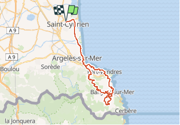
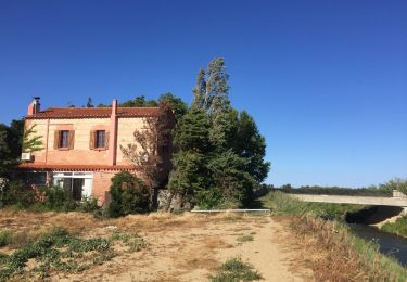
Trail Cycle of 72 km to be discovered at Occitania, Pyrénées-Orientales, Saint-Cyprien. This trail is proposed by bosses21.

Description

1. Col de las Portas - 77m
2. Col du Père Carnère - 69m
3. Col del Bast - 139m
4. Col de Las Vignas - 55m
6. Col de Llagastera - 256m
7. Col des Gascons - 386m
8. Col de Mollo - 229m
9. Coll de la Serra - 344m
10. Col de la Ruine - 265m
11. Col de Cassagne - 225m
12. Col d'en Calbo - 163m

Elevation profile

Points of interest

Point of interest Collioure - Col d'en Calbo - 163m - Photo
bosses21
Point of interest Collioure - Col de Cassagne - 225m - Photo
bosses21
Point of interest Collioure - Col de la Ruine - 265 m - Photo
bosses21
Point of interest Collioure - Coll de la Serra - 344m - Photo
bosses21
Point of interest Collioure - Col de Mollo - 229m - Photo
bosses21
Point of interest Port-Vendres - Col de las Portas - 77m - Photo
bosses21
Point of interest Banyuls-sur-Mer - Col del Bast - 139m - Photo
bosses21
BANYULS-SUR-MER 
Point of interest Banyuls-sur-Mer - Col de Las Vignas - 55m - Photo
bosses21
BANYULS-SUR-MER 
Point of interest Banyuls-sur-Mer - Col de Llagastera - 256m - Photo
bosses21
BANYULS-SUR-MER 
Point of interest Port-Vendres - Col des Gascons - 386m - Photo
bosses21

Positioning

Country:
France
Region :
Occitania
Department/Province :
Pyrénées-Orientales
Municipality :
Saint-Cyprien
Location:
Unknown
Start:(UTM)
500115 ; 4718989 (31T) N.

Trails nearby

Trail Walking Théza - 66 THEZA - CORNEILLA-DEL-VERCOL - Photo
Walking
jeff66

Walking

Easy
(2)
Théza, Occitania, Pyrénées-Orientales, France
7 km | 7.5 km-effort
1h 8min
Yes
Trail Walking Saint-Cyprien - SAINT-CYPRIEN 66 - front de mer - les CAPELLANS - Photo
Walking
jeff66

Walking

Easy
(2)
Saint-Cyprien, Occitania, Pyrénées-Orientales, France
9.9 km | 10.3 km-effort
2h 11min
Yes
Trail Equestrian Saint-Cyprien - bocal du Tech - Photo
Equestrian
sandymocko

Equestrian

Medium
(1)
Saint-Cyprien, Occitania, Pyrénées-Orientales, France
17 km | 17.7 km-effort
3h 20min
Yes
Trail Walking Saleilles - 66 SALEILLES - St-NAZAIRE, entre FOSSEILLE et REART - Photo
Walking
jeff66

Walking

Easy
(1)
Saleilles, Occitania, Pyrénées-Orientales, France
7.3 km | 7.7 km-effort
1h 8min
Yes
Trail Walking Corneilla-del-Vercol - thématique mo tescot du 18 02 2023 - Photo
Walking
66Gribouille83

Walking

Medium
(1)
Corneilla-del-Vercol, Occitania, Pyrénées-Orientales, France
8.9 km | 9.4 km-effort
1h 57min
Yes
Trail Walking Saint-Cyprien - 66 SAINT-CYPRIEN - ALENYA - LATOUR-BAS-ELNE - de berges en berges  - Photo
Walking
jeff66

Walking

Medium
Saint-Cyprien, Occitania, Pyrénées-Orientales, France
7.9 km | 8.3 km-effort
1h 16min
Yes
Trail Walking Saint-Cyprien - SAINT-CYPRIEN SUD 66 - Le bocal du TECH  - Photo
Walking
jeff66

Walking

Easy
(1)
Saint-Cyprien, Occitania, Pyrénées-Orientales, France
6.5 km | 6.8 km-effort
1h 20min
Yes
Trail Walking Argelès-sur-Mer - MAS LARRIEU - ARGELES-SUR-MER 66 - autour de la réserve naturelle, le littoral et retour par l'embouchure du TECH - Photo
Walking
jeff66

Walking

Medium
(1)
Argelès-sur-Mer, Occitania, Pyrénées-Orientales, France
13.6 km | 14.3 km-effort
2h 24min
Yes
Trail Walking Elne - ALENYA 66 - entre l'Agouille de la Mar et le Réart - Photo
Walking
jeff66

Walking

Easy
Elne, Occitania, Pyrénées-Orientales, France
12.6 km | 13.1 km-effort
1h 57min
Yes


Close
My subscriptions