Trail Walking Seillans - Les Bories de Seillans - Photo
© OpenStreetMap contributors
Length
Length
4.3 km
Max alt
Max alt
350 m
Uphill gradient
Uphill gradient
80 m
Km-Effort
Km-Effort  
5.3 km
Min alt
Min alt
292 m
Downhill gradient
Downhill gradient
80 m
Boucle
Boucle
No
Creation date :
2014-12-10 00:00:00.0
Updated on :
2014-12-10 00:00:00.0

(0 Reviews)

Walking
Walking
1h41
Difficulty : Unknown

Scan this QR Code to open this trail in the SityTrail application

FREE GPS app for hiking

Logo SityTrail SityTrail

IGN / Geographical institutes

Download SityTrail from the App Store Download SityTrail from Google Play

Logo SityTrail SityTrail World

The world is yours!

Download SityTrail from the App Store Download SityTrail from Google Play Download SityTrail on Huawei AppGallery

About

Trail Walking of 4.3 km to be discovered at Provence-Alpes-Côte d'Azur, Var, Seillans. This trail is proposed by ThierryMartin.

Elevation profile

Photos

Positioning

Country:
France
Region :
Provence-Alpes-Côte d'Azur
Department/Province :
Var
Municipality :
Seillans
Location:
Unknown
Start:(UTM)
310449 ; 4833634 (32T) N.

Comments

Please log in to post a review or rate the element


Se garer dans le parking de la chapelle de Notre-Dame de l'Ormeau. Au sortir du parking (Chapelle à votre droite), tournez à gauche et gravissez la petite pente qui rejoint la piste cyclable et prenez-la vers la gauche. Poursuivez jusqu'à la route asphaltée que vous longez vers la droite. Repérez un balisage jaune, qui quitte la voie principale asphaltée. A partir de là, suivez le balisage jaune.


Trails nearby

Trail Walking Seillans - z seillans 03-10-23 - Photo
Walking
cb8310

Walking

Easy
Seillans, Provence-Alpes-Côte d'Azur, Var, France
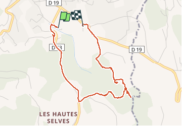
3.7 km | 4.6 km-effort
1h 36min
Yes
Trail Walking Fayence - FAYENCE - TOUR DES CHAPELLES  - Photo
Walking
jean-marie.parachini

Walking

Easy
Fayence, Provence-Alpes-Côte d'Azur, Var, France
16.2 km | 21 km-effort
8h 3min
Yes
Trail Walking Seillans - La Pigne - Photo
Walking
avdem

Walking

Easy
Seillans, Provence-Alpes-Côte d'Azur, Var, France
16.3 km | 23 km-effort
5h 51min
Yes
Trail Walking Seillans - Seillans - Fayence - Tourrettes - Callian - Photo
Walking
LtZIP

Walking

Easy
Seillans, Provence-Alpes-Côte d'Azur, Var, France
17.3 km | 23 km-effort
4h 35min
No
Trail Walking Fayence - Fayence - ND des Cyprès - ND des Selves - Photo
Walking
LtZIP

Walking

Easy
Fayence, Provence-Alpes-Côte d'Azur, Var, France
16.9 km | 22 km-effort
4h 27min
Yes
Trail Walking Seillans - 20190327 rando réelle Seillans - Photo
Walking
Sugg

Walking

Medium
Seillans, Provence-Alpes-Côte d'Azur, Var, France
14.1 km | 19.2 km-effort
5h 37min
No
Trail Walking Tourrettes - Tourrettes-Siagnole 27.04.16  - Photo
Walking
Sugg

Walking

Easy
(1)
Tourrettes, Provence-Alpes-Côte d'Azur, Var, France
18.3 km | 23 km-effort
5h 12min
Yes
Trail Walking Fayence - Fayence le circuit des chapelles - Photo
Walking
jean-marie.parachini

Walking

Medium
Fayence, Provence-Alpes-Côte d'Azur, Var, France
16.2 km | 21 km-effort
7h 28min
Yes
Trail Walking Tourrettes - z Tourrettes 28-09-21 - Photo
Walking
cb8310

Walking

Very easy
Tourrettes, Provence-Alpes-Côte d'Azur, Var, France
4.7 km | 5.3 km-effort
1h 33min
Yes


Close
My subscriptions