


Grands fonds st anne

sameja
User
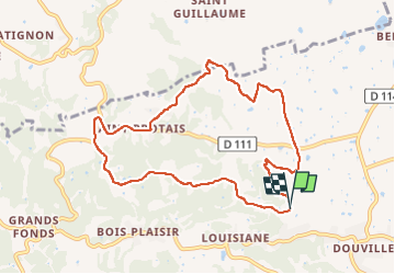

Length
12.6 km

Max alt
110 m

Uphill gradient
244 m
Km-Effort
15.8 km

Min alt
21 m

Downhill gradient
243 m
Boucle
Yes
Creation date :
2022-06-28 10:31:41.0
Updated on :
2022-06-28 12:18:50.878
1h43
Difficulty : Medium

FREE GPS app for hiking
 SityTrail
IGN / Geographical institutes
SityTrail Plus
The world is yours!
About
Trail Trail of 12.6 km to be discovered at Guadeloupe, Unknown, Sainte-Anne. This trail is proposed by sameja.
Description
La boucle
Photos


Positioning
Country:
France
Region :
Guadeloupe
Department/Province :
Unknown
Municipality :
Sainte-Anne
Location:
Unknown
Start:(Dec)
Start:(UTM)
672400 ; 1799179 (20Q) N.
Comments