


Montée au refuge vitorre emanuele

bern2zero
User
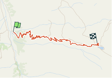

Length
4.3 km

Max alt
2720 m

Uphill gradient
717 m
Km-Effort
11.5 km

Min alt
1995 m

Downhill gradient
2 m
Boucle
No
Creation date :
2022-05-08 10:22:22.0
Updated on :
2022-07-01 11:22:30.269
3h28
Difficulty : Medium

FREE GPS app for hiking
 SityTrail
IGN / Geographical institutes
SityTrail Plus
The world is yours!
About
Trail Touring skiing of 4.3 km to be discovered at Aosta Valley, Unknown, Valsavarenche. This trail is proposed by bern2zero.
Positioning
Country:
Italy
Region :
Aosta Valley
Department/Province :
Unknown
Municipality :
Valsavarenche
Location:
Unknown
Start:(Dec)
Start:(UTM)
359890 ; 5041745 (32T) N.
Comments