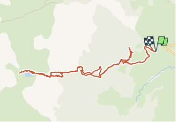
Trail Trail Lescun - Trail lac de Lhurs - Photo
 Fab-Oz
Fab-Oz

User

© OpenStreetMap contributors
Length
Length
13.4 km
Max alt
Max alt
1718 m
Uphill gradient
Uphill gradient
786 m
Km-Effort
Km-Effort  
24 km
Min alt
Min alt
990 m
Downhill gradient
Downhill gradient
786 m
Boucle
Boucle
Yes
Creation date :
2022-07-12 06:01:38.414
Updated on :
2022-07-12 09:00:50.533

(0 Reviews)

Trail
Trail
2h31
Difficulty : Medium

Scan this QR Code to open this trail in the SityTrail application

FREE GPS app for hiking

Logo SityTrail SityTrail

IGN / Geographical institutes

Download SityTrail from the App Store Download SityTrail from Google Play

Logo SityTrail SityTrail Plus

The world is yours!

Download SityTrail from the App Store Download SityTrail from Google Play Download SityTrail on Huawei AppGallery

About

Trail Trail of 13.4 km to be discovered at New Aquitaine, Pyrénées-Atlantiques, Lescun. This trail is proposed by Fab-Oz.

Description

Aller retour jusqu'au lac de Lhurs
Bonne partie de la montée en marchant mais descente entière en courant
Sympa la petite pause aux cabanes qui surplombent le lac de Lhurs
Pas de grosses difficultés si ce n'est le passage au milieu des rochers et même une partie de neige, mais qu'on peut éviter en suivant le sentier

Elevation profile

Positioning

Country:
France
Region :
New Aquitaine
Department/Province :
Pyrénées-Atlantiques
Municipality :
Lescun
Location:
Unknown
Start:(UTM)
690990 ; 4755434 (30T) N.


Close
My subscriptions