Trail Walking Pagny-sur-Moselle - Pagny-sur-Moselle - Photo
© OpenStreetMap contributors
Length
Length
16.3 km
Max alt
Max alt
349 m
Uphill gradient
Uphill gradient
320 m
Km-Effort
Km-Effort  
21 km
Min alt
Min alt
168 m
Downhill gradient
Downhill gradient
322 m
Boucle
Boucle
Yes
Creation date :
2014-12-10 00:00:00.0
Updated on :
2014-12-10 00:00:00.0

(0 Reviews)

Walking
Walking
4h31
Difficulty : Medium

Scan this QR Code to open this trail in the SityTrail application

FREE GPS app for hiking

Logo SityTrail SityTrail

IGN / Geographical institutes

Download SityTrail from the App Store Download SityTrail from Google Play

Logo SityTrail SityTrail World

The world is yours!

Download SityTrail from the App Store Download SityTrail from Google Play Download SityTrail on Huawei AppGallery

About

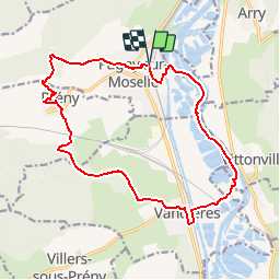
Trail Walking of 16.3 km to be discovered at Grand Est, Meurthe-et-Moselle, Pagny-sur-Moselle. This trail is proposed by DanielROLLET.

Description

8 août 2014. Reco avec Marie
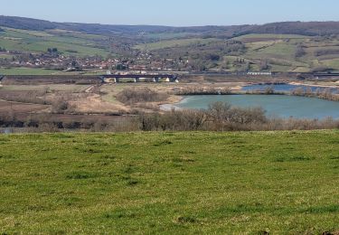
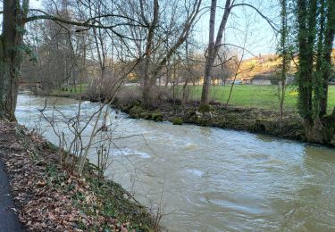
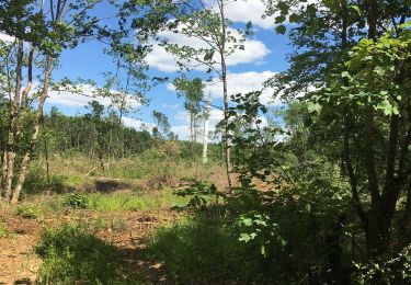
Départ et retour à la gare de Pagny. Montée vers Prény par les rues de Pagny puis par le GR5. A voir chpateau de Prény avec un point d'eau. Puis continuer sur le GR5, passer au-dessus de la LGV (vue sur le racc L12 et les opuvrages) poursuivre sur le GR5 et le quitter pour redescendre sur Vandières (1 bar et 1 auberge) Franchir le passage à niveau puis le canal et cheminer entre gravières et la Moselle. Puis repasser le canal et franchir le passage à niveau de Pagny et arrivée à la gare.
Attention pas d'abri en route.

Elevation profile

Points of interest

Point of interest Vandières - bar le coyottePoint 1 - Photo
DanielROLLET

Positioning

Country:
France
Region :
Grand Est
Department/Province :
Meurthe-et-Moselle
Municipality :
Pagny-sur-Moselle
Location:
Unknown
Start:(UTM)
282352 ; 5430066 (32U) N.

Trails nearby

Trail On foot Arry - Circuit d'Arry Nord - Photo
On foot
PRO

On foot

Easy
Arry, Grand Est, Moselle, France
3.4 km | 4.2 km-effort
57min
No
Trail Walking Pagny-sur-Moselle - Pagny sur Moselle - Photo
Walking
joelclaudel

Walking

Very easy
(1)
Pagny-sur-Moselle, Grand Est, Meurthe-et-Moselle, France
18.1 km | 23 km-effort
4h 55min
Yes
Trail Walking Arry - Arry - côte Saint Pierre - Vezon - Marieulles - Lorry Mardigny - Arry  - Photo
Walking
jean-marie.parachini

Walking

Medium
Arry, Grand Est, Moselle, France
13.9 km | 18 km-effort
24h 12min
Yes
Trail Walking Champey-sur-Moselle - CHAMPEY - LA FRONTIERE - Photo
Walking
jean-marie.parachini

Walking

Easy
Champey-sur-Moselle, Grand Est, Meurthe-et-Moselle, France
10.7 km | 14.5 km-effort
3h 31min
Yes
Trail Walking Arnaville - ARNAVILLE - LES AÏTRES MEDIEVAUX - Photo
Walking
jean-marie.parachini

Walking

Easy
Arnaville, Grand Est, Meurthe-et-Moselle, France
12.7 km | 15.6 km-effort
3h 51min
Yes
Trail Walking Arnaville - ARNAVILLE - LA VALLEE DU RUPT DE MAD - Photo
Walking
jean-marie.parachini

Walking

Easy
Arnaville, Grand Est, Meurthe-et-Moselle, France
9.9 km | 13.5 km-effort
3h 55min
Yes
Trail Walking Pagny-sur-Moselle - PAGNY SUR MOSELLE - VAL ET PLATEAU - Photo
Walking
jean-marie.parachini

Walking

Medium
Pagny-sur-Moselle, Grand Est, Meurthe-et-Moselle, France
18.1 km | 23 km-effort
6h 46min
Yes
Trail Walking Prény - Forêt de Preny dévastée quelle dommage - Photo
Walking
bitiba

Walking

Medium
Prény, Grand Est, Meurthe-et-Moselle, France
7.4 km | 9.7 km-effort
1h 14min
No
Trail Walking Prény - Marche Prény 2017 - Photo
Walking
pgydbt

Walking

Medium
(1)
Prény, Grand Est, Meurthe-et-Moselle, France
9.5 km | 13 km-effort
2h 41min
Yes


Close
My subscriptions