Trail Walking Sainte-Ode - Beauplateau - Le sentier du Coprin (GTA 4) - Photo

Beauplateau - Le sentier du Coprin (GTA 4)

Randonnées de la Grande Forêt de Saint-Hubert GUIDE+

© OpenStreetMap contributors
Length
Length
16.6 km
Max alt
Max alt
530 m
Uphill gradient
Uphill gradient
276 m
Km-Effort
Km-Effort  
20 km
Min alt
Min alt
432 m
Downhill gradient
Downhill gradient
280 m
Boucle
Boucle
Yes
Signpost
Signpost
Creation date :
2017-06-07 00:00:00.0
Updated on :
2017-06-07 00:00:00.0

(2 Reviews)

Walking
Walking
4h20
Difficulty : Very difficult

Scan this QR Code to open this trail in the SityTrail application

FREE GPS app for hiking

Logo SityTrail SityTrail

IGN / Geographical institutes

Download SityTrail from the App Store Download SityTrail from Google Play

Logo SityTrail SityTrail World

The world is yours!

Download SityTrail from the App Store Download SityTrail from Google Play Download SityTrail on Huawei AppGallery

About

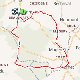
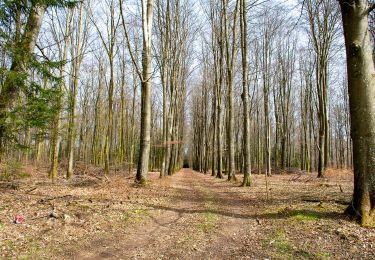
Trail Walking of 16.6 km to be discovered at Wallonia, Luxembourg, Sainte-Ode. This trail is proposed by La Grande Forêt de Saint-Hubert.

Description

Cet itinéraire est le plus court du Sentier de l'Ourthe et du Laval.

Au départ de Beauplateau vous rejoindrez Morhet en randonnant essentiellement dans les bois. Vous passerez ensuite par deux villages et un hameau.

Extrait de la carte IGN des promenades de la commune de Sainte-Ode, échelle 1:25 000, vendue à 8,00 €.

Concepteur: Syndicat d'Initiative de Sainte-Ode

Elevation profile

Photos

Points of interest

Point of interest Sainte-Ode - Départ de la randonnée - Photo
La Grande Forêt de Saint-Hubert
Point of interest Sainte-Ode - Le village de Magerotte - Photo
La Grande Forêt de Saint-Hubert
Point of interest Vaux-sur-Sûre - Le village de Morhet - Photo
La Grande Forêt de Saint-Hubert
VAUX-SUR-SÛRE 

Positioning

Country:
Belgium
Region :
Wallonia
Department/Province :
Luxembourg
Municipality :
Sainte-Ode
Location:
Tillet
Start:(UTM)
681385 ; 5541276 (31U) N.

Comments

Please log in to post a review or rate the element


Trails nearby

Trail On foot Libramont-Chevigny - Remagne étang gpx - Photo
On foot
GUIDE+

On foot

Easy
(1)
Libramont-Chevigny, Wallonia, Luxembourg, Belgium
7.5 km | 9.5 km-effort
2h 9min
Yes
Trail Walking Sainte-Ode - RB-LUX-08 - Raccourci - De part et d’autre de l’Ourthe occidentale - Photo
Walking
PRO

Walking

Difficult
(2)
Sainte-Ode, Wallonia, Luxembourg, Belgium
15.2 km | 18.6 km-effort
4h 13min
Yes
Trail Walking Sainte-Ode - Tonny - Promenade de Tonny (A6) - Photo
Walking
GUIDE+

Walking

Medium
(3)
Sainte-Ode, Wallonia, Luxembourg, Belgium
9.5 km | 12.2 km-effort
2h 36min
Yes
Trail Walking Sainte-Ode - Beauplateau - Promenade du Pleurotte (T7) - Photo
Walking
GUIDE+

Walking

Medium
(2)
Sainte-Ode, Wallonia, Luxembourg, Belgium
5.5 km | 6.9 km-effort
1h 29min
Yes
Trail Walking Sainte-Ode - Amberloup, Natura 2000 - Des sites qui valent le détour. Lx11 - Photo
Walking
GUIDE+

Walking

Easy
(4)
Sainte-Ode, Wallonia, Luxembourg, Belgium
4.2 km | 5 km-effort
1h 6min
Yes
Trail Walking Sainte-Ode - RB-LUX-08 - De part et d’autre de l’Ourthe occidentale - Photo
Walking
PRO

Walking

Medium
(1)
Sainte-Ode, Wallonia, Luxembourg, Belgium
23 km | 29 km-effort
6h 14min
Yes
Trail Walking Sainte-Ode - Tonny - Promenade de bois Cousin (A7) - Photo
Walking
GUIDE+

Walking

Medium
(2)
Sainte-Ode, Wallonia, Luxembourg, Belgium
5.8 km | 7.9 km-effort
1h 40min
Yes
Trail Walking Sainte-Ode - Magerotte - Promenade des Haies de Magery (T4) - Photo
Walking
GUIDE+

Walking

Medium
(3)
Sainte-Ode, Wallonia, Luxembourg, Belgium
9.3 km | 11.4 km-effort
2h 29min
Yes
Trail Walking Sainte-Ode - Rechrival - Promenade des Haies des Valets (T3) - Photo
Walking
GUIDE+

Walking

Medium
(1)
Sainte-Ode, Wallonia, Luxembourg, Belgium
8.5 km | 10.1 km-effort
2h 12min
Yes


Close
My subscriptions