Trail Walking Saint-Jean-d'Aulps - Lac de Damoz des Moulins - Photo
© OpenStreetMap contributors
Length
Length
11.4 km
Max alt
Max alt
1732 m
Uphill gradient
Uphill gradient
771 m
Km-Effort
Km-Effort  
22 km
Min alt
Min alt
1024 m
Downhill gradient
Downhill gradient
768 m
Boucle
Boucle
Yes
Creation date :
2014-12-10 00:00:00.0
Updated on :
2014-12-10 00:00:00.0

(0 Reviews)

Walking
Walking
3h09
Difficulty : Medium

Scan this QR Code to open this trail in the SityTrail application

FREE GPS app for hiking

Logo SityTrail SityTrail

IGN / Geographical institutes

Download SityTrail from the App Store Download SityTrail from Google Play

Logo SityTrail SityTrail World

The world is yours!

Download SityTrail from the App Store Download SityTrail from Google Play Download SityTrail on Huawei AppGallery

About

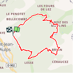
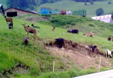
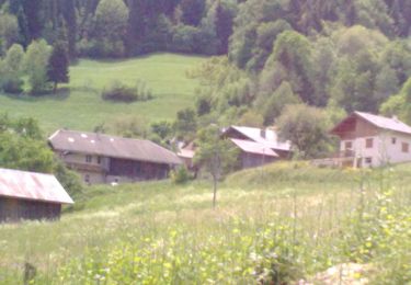
Trail Walking of 11.4 km to be discovered at Auvergne-Rhône-Alpes, Upper Savoy, Saint-Jean-d'Aulps. This trail is proposed by thierry13710.

Description

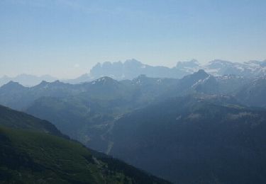
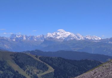
Circuit depuis le Mont d'Evian jusqu'au lac de Damoz des Moulins. Belle vue sur le lac au col de Crève Coeur

Elevation profile

Photos

Positioning

Country:
France
Region :
Auvergne-Rhône-Alpes
Department/Province :
Upper Savoy
Municipality :
Saint-Jean-d'Aulps
Location:
Unknown
Start:(Dec)
Start:(UTM)
319655 ; 5123298 (32T) N.

Trails nearby

Trail Walking Abondance - Le Roc de Tavaneuse 2156 m, depuis Prétairié - Photo
Walking
tracegps

Walking

Medium
(1)
Abondance, Auvergne-Rhône-Alpes, Upper Savoy, France
8.2 km | 21 km-effort
5h 30min
Yes
Trail On foot Abondance - Itineraire des bords de Dranse - Photo
On foot
PRO

On foot

Easy
Abondance, Auvergne-Rhône-Alpes, Upper Savoy, France
3.6 km | 4.4 km-effort
59min
No
Trail On foot Saint-Jean-d'Aulps - Tour des Portes du Soleil - Photo
On foot
PRO

On foot

Very difficult
Saint-Jean-d'Aulps, Auvergne-Rhône-Alpes, Upper Savoy, France
34 km | 66 km-effort
15h 3min
No
Trail Walking Le Biot - La Pointe de la Croix depuis le Biot - Photo
Walking
thierry13710

Walking

Medium
Le Biot, Auvergne-Rhône-Alpes, Upper Savoy, France
19.3 km | 34 km-effort
7h 2min
Yes
Trail Walking Saint-Jean-d'Aulps - Pointe de Nantaux - Photo
Walking
yoann.main

Walking

Medium
Saint-Jean-d'Aulps, Auvergne-Rhône-Alpes, Upper Savoy, France
5.6 km | 18.3 km-effort
2h 21min
No
Trail Walking Abondance - lac de taverneuse - Photo
Walking
raph74930

Walking

Medium
(1)
Abondance, Auvergne-Rhône-Alpes, Upper Savoy, France
5.4 km | 12.4 km-effort
2h 37min
No
Trail Walking Saint-Jean-d'Aulps - St Jean D'Aulps - Abondance - St Jean D'Aulps - Photo
Walking
tracegps

Walking

Difficult
Saint-Jean-d'Aulps, Auvergne-Rhône-Alpes, Upper Savoy, France
24 km | 42 km-effort
5h 0min
Yes
Trail Walking Saint-Jean-d'Aulps - La Grande Terche - Le Biot - Le Sey - La Grande Terche - Photo
Walking
tracegps

Walking

Medium
Saint-Jean-d'Aulps, Auvergne-Rhône-Alpes, Upper Savoy, France
18.1 km | 27 km-effort
3h 30min
Yes
Trail Walking Saint-Jean-d'Aulps - col de Ratti - Photo
Walking
davvin13

Walking

Difficult
Saint-Jean-d'Aulps, Auvergne-Rhône-Alpes, Upper Savoy, France
7.3 km | 14.7 km-effort
4h 20min
No


Close
My subscriptions