


Martel 11--300

pidjam
User
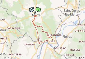

Length
11.2 km

Max alt
301 m

Uphill gradient
303 m
Km-Effort
15.3 km

Min alt
110 m

Downhill gradient
300 m
Boucle
Yes
Creation date :
2022-08-09 08:40:51.072
Updated on :
2022-08-09 08:41:30.193
3h28
Difficulty : Difficult

FREE GPS app for hiking
 SityTrail
IGN / Geographical institutes
SityTrail Plus
The world is yours!
About
Trail Walking of 11.2 km to be discovered at Occitania, Lot, Martel. This trail is proposed by pidjam.
Description
Randonnée à Martel vers Gluges
Positioning
Country:
France
Region :
Occitania
Department/Province :
Lot
Municipality :
Martel
Location:
Unknown
Start:(Dec)
Start:(UTM)
390139 ; 4976918 (31T) N.
Comments