


depart gonsans version 2 rando du 16-8-2022

gerardmicheline
User
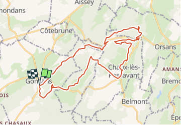

Length
20 km

Max alt
609 m

Uphill gradient
382 m
Km-Effort
25 km

Min alt
430 m

Downhill gradient
378 m
Boucle
Yes
Creation date :
2022-08-15 14:20:24.83
Updated on :
2022-08-15 14:21:25.8
5h45
Difficulty : Very difficult

FREE GPS app for hiking
 SityTrail
IGN / Geographical institutes
SityTrail Plus
The world is yours!
About
Trail Walking of 20 km to be discovered at Bourgogne-Franche-Comté, Doubs, Gonsans. This trail is proposed by gerardmicheline.
Positioning
Country:
France
Region :
Bourgogne-Franche-Comté
Department/Province :
Doubs
Municipality :
Gonsans
Location:
Unknown
Start:(Dec)
Start:(UTM)
295740 ; 5234227 (32T) N.
Comments