Trail Other activity Lauterbrunnen - Kleine Scheidegg - Ski - Photo
 Dgubler
Dgubler

User

© OpenStreetMap contributors
Length
Length
51 km
Max alt
Max alt
2399 m
Uphill gradient
Uphill gradient
4716 m
Km-Effort
Km-Effort  
118 km
Min alt
Min alt
941 m
Downhill gradient
Downhill gradient
5832 m
Boucle
Boucle
No
Creation date :
2014-12-10 00:00:00.0
Updated on :
2014-12-10 00:00:00.0

(0 Reviews)

Other activity
Other activity
--
Difficulty : Unknown

Scan this QR Code to open this trail in the SityTrail application

FREE GPS app for hiking

Logo SityTrail SityTrail

IGN / Geographical institutes

Download SityTrail from the App Store Download SityTrail from Google Play

Logo SityTrail SityTrail World

The world is yours!

Download SityTrail from the App Store Download SityTrail from Google Play Download SityTrail on Huawei AppGallery

About

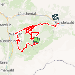
Trail Other activity of 51 km to be discovered at Bern, Interlaken-Oberhasli administrative district, Lauterbrunnen. This trail is proposed by Dgubler.

Description

Il est possible de skier toute la journée dans cette région sans passer deux fois par la même piste. Toutefois, la redoutée "Distelboden" nous a vu passer plusieurs fois...
At the foot of the dreadful Eiger North Face. Here you can ski the whole day without going twice on the same track. Unless you want to do so, of course. In our case, we can''t help being tested several times by the frightening Thistle Bottom track!

Elevation profile

Positioning

Country:
Switzerland
Region :
Bern
Department/Province :
Interlaken-Oberhasli administrative district
Municipality :
Lauterbrunnen
Location:
Unknown
Start:(UTM)
420433 ; 5159609 (32T) N.

Trails nearby

Trail Other activity Lauterbrunnen - ViaRegio_Jungfrau_5 - Photo
Other activity
GUIDE+

Other activity

Very easy
Lauterbrunnen, Bern, Interlaken-Oberhasli administrative district, Switzerland
14.7 km | 34 km-effort
8h 53min
No
Trail Other activity Grindelwald - y10_kleine_scheidegg - Photo
Other activity
GUIDE+

Other activity

Very easy
Grindelwald, Bern, Interlaken-Oberhasli administrative district, Switzerland
11.5 km | 15.6 km-effort
3h 21min
No
Trail Walking Lauterbrunnen - hike02 - Photo
Walking
GUIDE+

Walking

Very easy
Lauterbrunnen, Bern, Interlaken-Oberhasli administrative district, Switzerland
6.6 km | 14.5 km-effort
Unknown
No
Trail Mountain bike Lauterbrunnen - Bike32891 - Photo
Mountain bike
GUIDE+

Mountain bike

Very easy
Lauterbrunnen, Bern, Interlaken-Oberhasli administrative district, Switzerland
27 km | 42 km-effort
Unknown
Yes
Trail Walking Lauterbrunnen - Tal der 72 Wasserfälle: Lauterbrunnen-Stechelberg - Photo
Walking
GUIDE+

Walking

Very easy
Lauterbrunnen, Bern, Interlaken-Oberhasli administrative district, Switzerland
8 km | 10.5 km-effort
Unknown
No
Trail Walking Fieschertal - sf_e10c - Photo
Walking
GUIDE+

Walking

Very easy
Fieschertal, Valais/Wallis, Goms, Switzerland
29 km | 43 km-effort
7h 37min
No
Trail Walking Lauterbrunnen - sf_e10a - Photo
Walking
GUIDE+

Walking

Very easy
Lauterbrunnen, Bern, Interlaken-Oberhasli administrative district, Switzerland
11.8 km | 18.5 km-effort
3h 6min
No
Trail Walking Lauterbrunnen - st_eigertrail - Photo
Walking
GUIDE+

Walking

Very easy
Lauterbrunnen, Bern, Interlaken-Oberhasli administrative district, Switzerland
7.3 km | 12.9 km-effort
Unknown
No
Trail Other activity Lauterbrunnen - w10_06_eigertrail - Photo
Other activity
GUIDE+

Other activity

Very easy
Lauterbrunnen, Bern, Interlaken-Oberhasli administrative district, Switzerland
5.7 km | 8.6 km-effort
1h 41min
No


Close
My subscriptions