


rando faverolles en berry

lecmic
User
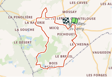

Length
18.2 km

Max alt
154 m

Uphill gradient
166 m
Km-Effort
20 km

Min alt
102 m

Downhill gradient
167 m
Boucle
Yes
Creation date :
2022-08-28 05:07:15.869
Updated on :
2022-08-28 08:30:07.554
3h17
Difficulty : Easy

FREE GPS app for hiking
 SityTrail
IGN / Geographical institutes
SityTrail Plus
The world is yours!
About
Trail Walking of 18.2 km to be discovered at Centre-Loire Valley, Indre, Villentrois-Faverolles-en-Berry. This trail is proposed by lecmic.
Description
rando Benjamin rabier
Positioning
Country:
France
Region :
Centre-Loire Valley
Department/Province :
Indre
Municipality :
Villentrois-Faverolles-en-Berry
Location:
Faverolles-en-Berry
Start:(Dec)
Start:(UTM)
379093 ; 5225252 (31T) N.
Comments