


Col d’Anterne par refuge Alfred Wills

GOHIER
User
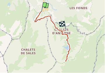

Length
14.3 km

Max alt
2253 m

Uphill gradient
1300 m
Km-Effort
29 km

Min alt
1198 m

Downhill gradient
604 m
Boucle
No
Creation date :
2022-09-09 08:18:37.0
Updated on :
2022-09-10 18:26:43.978
21h51
Difficulty : Medium

FREE GPS app for hiking
 SityTrail
IGN / Geographical institutes
SityTrail Plus
The world is yours!
About
Trail Walking of 14.3 km to be discovered at Auvergne-Rhône-Alpes, Upper Savoy, Sixt-Fer-à-Cheval. This trail is proposed by GOHIER.
Description
1200 m! Très bonne fondue!
Positioning
Country:
France
Region :
Auvergne-Rhône-Alpes
Department/Province :
Upper Savoy
Municipality :
Sixt-Fer-à-Cheval
Location:
Unknown
Start:(Dec)
Start:(UTM)
327208 ; 5098770 (32T) N.
Comments