


20221013 grand pre

Jeanclaudebic
User
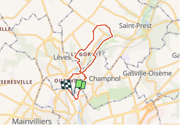

Length
11.2 km

Max alt
158 m

Uphill gradient
132 m
Km-Effort
13 km

Min alt
116 m

Downhill gradient
133 m
Boucle
Yes
Creation date :
2022-10-13 06:58:24.728
Updated on :
2022-10-13 09:04:25.708
2h05
Difficulty : Difficult

FREE GPS app for hiking
 SityTrail
IGN / Geographical institutes
SityTrail Plus
The world is yours!
About
Trail Walking of 11.2 km to be discovered at Centre-Loire Valley, Eure-et-Loir, Chartres. This trail is proposed by Jeanclaudebic.
Positioning
Country:
France
Region :
Centre-Loire Valley
Department/Province :
Eure-et-Loir
Municipality :
Chartres
Location:
Unknown
Start:(Dec)
Start:(UTM)
388135 ; 5368616 (31U) N.
Comments