


trtr

lm178
User

Length
20 km

Max alt
150 m

Uphill gradient
173 m
Km-Effort
22 km

Min alt
86 m

Downhill gradient
169 m
Boucle
No
Creation date :
2022-10-26 07:46:04.065
Updated on :
2022-10-26 13:36:08.022
4h39
Difficulty : Very easy

FREE GPS app for hiking
 SityTrail
IGN / Geographical institutes
SityTrail Plus
The world is yours!
About
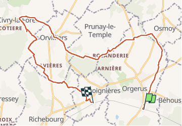
Trail Walking of 20 km to be discovered at Ile-de-France, Yvelines, Orgerus. This trail is proposed by lm178.
Positioning
Country:
France
Region :
Ile-de-France
Department/Province :
Yvelines
Municipality :
Orgerus
Location:
Unknown
Start:(Dec)
Start:(UTM)
404810 ; 5408986 (31U) N.
Comments