


Sortie Montgolfière

pconte
User

Length
9.2 km

Max alt
1153 m

Uphill gradient
326 m
Km-Effort
13.6 km

Min alt
994 m

Downhill gradient
359 m
Boucle
No
Creation date :
2022-10-28 07:43:11.0
Updated on :
2022-10-28 09:04:12.227
1h20
Difficulty : Unknown

FREE GPS app for hiking
 SityTrail
IGN / Geographical institutes
SityTrail Plus
The world is yours!
About
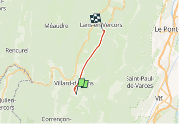
Trail Hot-air balloon of 9.2 km to be discovered at Auvergne-Rhône-Alpes, Isère, Villard-de-Lans. This trail is proposed by pconte.
Positioning
Country:
France
Region :
Auvergne-Rhône-Alpes
Department/Province :
Isère
Municipality :
Villard-de-Lans
Location:
Unknown
Start:(Dec)
Start:(UTM)
701132 ; 4992753 (31T) N.
Comments