


Latour de Carol Puigcerda AR

pidjam
User
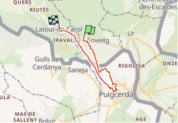

Length
10.5 km

Max alt
1254 m

Uphill gradient
146 m
Km-Effort
12.4 km

Min alt
1166 m

Downhill gradient
132 m
Boucle
No
Creation date :
2022-12-03 12:34:36.137
Updated on :
2022-12-03 15:37:18.458
3h02
Difficulty : Easy

FREE GPS app for hiking
 SityTrail
IGN / Geographical institutes
SityTrail Plus
The world is yours!
About
Trail Walking of 10.5 km to be discovered at Occitania, Pyrénées-Orientales, Enveitg. This trail is proposed by pidjam.
Positioning
Country:
France
Region :
Occitania
Department/Province :
Pyrénées-Orientales
Municipality :
Enveitg
Location:
Unknown
Start:(Dec)
Start:(UTM)
409969 ; 4701327 (31T) N.
Comments