


Le Meillarot

pconte
User
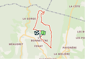

Length
6.6 km

Max alt
1373 m

Uphill gradient
322 m
Km-Effort
10.9 km

Min alt
1058 m

Downhill gradient
321 m
Boucle
Yes
Creation date :
2023-03-05 09:10:50.0
Updated on :
2023-03-05 17:03:53.547
3h37
Difficulty : Difficult

FREE GPS app for hiking
 SityTrail
IGN / Geographical institutes
SityTrail Plus
The world is yours!
About
Trail Walking of 6.6 km to be discovered at Auvergne-Rhône-Alpes, Isère, Villard-de-Lans. This trail is proposed by pconte.
Description
Rando Christian AGOPOP
Positioning
Country:
France
Region :
Auvergne-Rhône-Alpes
Department/Province :
Isère
Municipality :
Villard-de-Lans
Location:
Unknown
Start:(Dec)
Start:(UTM)
699477 ; 4995445 (31T) N.
Comments