


Aurons - Tallagard - les Gaussiers

Berpav
User
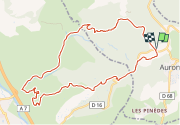

Length
12.6 km

Max alt
317 m

Uphill gradient
257 m
Km-Effort
16 km

Min alt
123 m

Downhill gradient
257 m
Boucle
Yes
Creation date :
2023-03-23 16:29:07.172
Updated on :
2023-03-23 16:32:10.476
3h37
Difficulty : Difficult

FREE GPS app for hiking
 SityTrail
IGN / Geographical institutes
SityTrail Plus
The world is yours!
About
Trail Walking of 12.6 km to be discovered at Provence-Alpes-Côte d'Azur, Bouches-du-Rhône, Aurons. This trail is proposed by Berpav.
Description
visite des bories
Positioning
Country:
France
Region :
Provence-Alpes-Côte d'Azur
Department/Province :
Bouches-du-Rhône
Municipality :
Aurons
Location:
Unknown
Start:(Dec)
Start:(UTM)
673477 ; 4837414 (31T) N.
Comments