Trail Walking Saint-Étienne-lès-Remiremont - Vers la Tête des Cuveaux - Photo
© OpenStreetMap contributors
Length
Length
9 km
Max alt
Max alt
788 m
Uphill gradient
Uphill gradient
256 m
Km-Effort
Km-Effort  
12.4 km
Min alt
Min alt
653 m
Downhill gradient
Downhill gradient
257 m
Boucle
Boucle
Yes
Creation date :
2014-12-10 00:00:00.0
Updated on :
2014-12-10 00:00:00.0

(1 Reviews)

Walking
Walking
2h30
Difficulty : Easy

Scan this QR Code to open this trail in the SityTrail application

FREE GPS app for hiking

Logo SityTrail SityTrail

IGN / Geographical institutes

Download SityTrail from the App Store Download SityTrail from Google Play

Logo SityTrail SityTrail World

The world is yours!

Download SityTrail from the App Store Download SityTrail from Google Play Download SityTrail on Huawei AppGallery

About

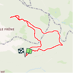
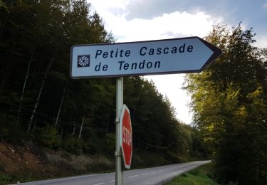
Trail Walking of 9 km to be discovered at Grand Est, Vosges, Saint-Étienne-lès-Remiremont. This trail is proposed by jeanclaude12.

Description

Partir du Haut des Viaux vers la Croix de Groshaut et la Tête des Cuveaux et revenir vers le Col du Singe en contournant le Moury puis s'arrêter aux Roches des Champs Dolents.

Elevation profile

Photos

Points of interest

Point of interest Éloyes - Croix de Groshaut - Photo
jeanclaude12
Point of interest Éloyes - Tête des Cuveaux - Photo
jeanclaude12
Point of interest Saint-Étienne-lès-Remiremont - Roches Dolents - Photo
jeanclaude12
SAINT-ÉTIENNE-LÈS-REMIREMONT 

Positioning

Country:
France
Region :
Grand Est
Department/Province :
Vosges
Municipality :
Saint-Étienne-lès-Remiremont
Location:
Unknown
Start:(UTM)
324280 ; 5327470 (32U) N.

Comments

Please log in to post a review or rate the element


Trails nearby

Trail Walking Tendon - Cascades de Tendon - Trou de l'Enfer - Roches de la Moulure - Photo
Walking
Bart2015

Walking

Medium
(3)
Tendon, Grand Est, Vosges, France
20 km | 28 km-effort
5h 33min
Yes
Trail Walking Éloyes - eloyes champ dolant - Photo
Walking
lacote

Walking

Medium
(2)
Éloyes, Grand Est, Vosges, France
8.2 km | 12.4 km-effort
2h 26min
Yes
Trail Walking Le Tholy - tendon  - Photo
Walking
michelelfn

Walking

Easy
(4)
Le Tholy, Grand Est, Vosges, France
9.1 km | 12.9 km-effort
3h 1min
Yes
Trail Walking Tendon - cascade  - Photo
Walking
aubr

Walking

Very difficult
Tendon, Grand Est, Vosges, France
20 km | 25 km-effort
1h 51min
No
Trail Walking Tendon - cascade du tendon - Photo
Walking
ghislaine61

Walking

Difficult
Tendon, Grand Est, Vosges, France
8.6 km | 12.2 km-effort
2h 44min
Yes
Trail Walking Le Syndicat - plaine cleurie - la bresse - Photo
Walking
demange gerald

Walking

Very difficult
Le Syndicat, Grand Est, Vosges, France
23 km | 36 km-effort
5h 34min
No
Trail Walking Saint-Étienne-lès-Remiremont - Les cuveaux à Eloyes - Photo
Walking
regish54

Walking

Easy
Saint-Étienne-lès-Remiremont, Grand Est, Vosges, France
4.5 km | 5.6 km-effort
1h 23min
No
Trail Walking Jarménil - haut jarmenil 2 - Photo
Walking
lacote

Walking

Medium
(1)
Jarménil, Grand Est, Vosges, France
12.3 km | 16.8 km-effort
2h 39min
Yes
Trail Walking Cleurie - Sur le sentier du 9ème RAMA - Photo
Walking
jeanclaude12

Walking

Easy
Cleurie, Grand Est, Vosges, France
6.2 km | 8.3 km-effort
3h 29min
Yes


Close
My subscriptions