


MASSINGY 20 Km

djeepee74
User
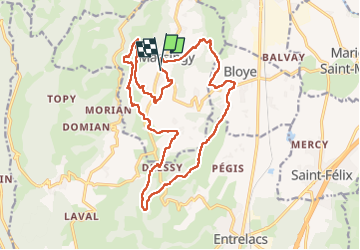

Length
19.7 km

Max alt
693 m

Uphill gradient
586 m
Km-Effort
28 km

Min alt
374 m

Downhill gradient
580 m
Boucle
Yes
Creation date :
2023-04-10 06:42:14.262
Updated on :
2023-04-11 09:33:49.407
5h45
Difficulty : Difficult

FREE GPS app for hiking
 SityTrail
IGN / Geographical institutes
SityTrail Plus
The world is yours!
About
Trail Walking of 19.7 km to be discovered at Auvergne-Rhône-Alpes, Upper Savoy, Massingy. This trail is proposed by djeepee74.
Description
BOUCLE ... live 20230410
05:45 en déplacement effectif.
Positioning
Country:
France
Region :
Auvergne-Rhône-Alpes
Department/Province :
Upper Savoy
Municipality :
Massingy
Location:
Unknown
Start:(Dec)
Start:(UTM)
726598 ; 5078948 (31T) N.
Comments