


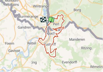
Wikiloc - Moselle

collignpn
User GUIDE

Length
33 km

Max alt
391 m

Uphill gradient
890 m
Km-Effort
45 km

Min alt
140 m

Downhill gradient
894 m
Boucle
Yes
Creation date :
2023-05-11 10:37:08.088
Updated on :
2023-05-13 05:53:46.806
10h14
Difficulty : Very difficult
0m
Difficulty : Medium

FREE GPS app for hiking
 SityTrail
IGN / Geographical institutes
SityTrail Plus
The world is yours!
About
Trail Walking of 33 km to be discovered at Unknown, Canton Remich, Schengen. This trail is proposed by collignpn.
Positioning
Country:
Luxembourg
Region :
Unknown
Department/Province :
Canton Remich
Municipality :
Schengen
Location:
Unknown
Start:(Dec)
Start:(UTM)
309203 ; 5483111 (32U) N.
Comments