


Entracque cascade tendis

SaintEloi4
User
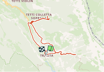

Length
10.8 km

Max alt
1346 m

Uphill gradient
422 m
Km-Effort
16.5 km

Min alt
1064 m

Downhill gradient
430 m
Boucle
Yes
Creation date :
2023-07-12 07:52:34.0
Updated on :
2023-07-12 13:21:09.705
3h46
Difficulty : Medium

FREE GPS app for hiking
 SityTrail
IGN / Geographical institutes
SityTrail Plus
The world is yours!
About
Trail Walking of 10.8 km to be discovered at Piemont, Cuneo, Entracque. This trail is proposed by SaintEloi4.
Positioning
Country:
Italy
Region :
Piemont
Department/Province :
Cuneo
Municipality :
Entracque
Location:
Unknown
Start:(Dec)
Start:(UTM)
374669 ; 4896978 (32T) N.
Comments