


Aix Venergues 1070m+

ericberlin
User
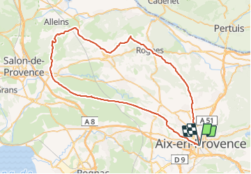

Length
75 km

Max alt
494 m

Uphill gradient
1070 m
Km-Effort
89 km

Min alt
80 m

Downhill gradient
1070 m
Boucle
Yes
Creation date :
2023-07-31 14:49:33.589
Updated on :
2023-07-31 14:50:26.704
5h23
Difficulty : Very difficult

FREE GPS app for hiking
 SityTrail
IGN / Geographical institutes
SityTrail Plus
The world is yours!
About
Trail Road bike of 75 km to be discovered at Provence-Alpes-Côte d'Azur, Bouches-du-Rhône, Aix-en-Provence. This trail is proposed by ericberlin.
Positioning
Country:
France
Region :
Provence-Alpes-Côte d'Azur
Department/Province :
Bouches-du-Rhône
Municipality :
Aix-en-Provence
Location:
Unknown
Start:(Dec)
Start:(UTM)
697635 ; 4822158 (31T) N.
Comments