Trail Walking Civrieux-d'Azergues - A_CIVRIEUX D'AZERGUES 69380 Dommartin - Bruyère Marand - Photo

A_CIVRIEUX D'AZERGUES 69380 Dommartin - Bruyère Marand

 ANDREJAC
ANDREJAC

User

© OpenStreetMap contributors
Length
Length
9.7 km
Max alt
Max alt
298 m
Uphill gradient
Uphill gradient
160 m
Km-Effort
Km-Effort  
11.9 km
Min alt
Min alt
194 m
Downhill gradient
Downhill gradient
161 m
Boucle
Boucle
Yes
Creation date :
2015-02-24 00:00:00.0
Updated on :
2015-02-24 00:00:00.0

(0 Reviews)

Walking
Walking
3h00
Difficulty : Easy

Scan this QR Code to open this trail in the SityTrail application

FREE GPS app for hiking

Logo SityTrail SityTrail

IGN / Geographical institutes

Download SityTrail from the App Store Download SityTrail from Google Play

Logo SityTrail SityTrail World

The world is yours!

Download SityTrail from the App Store Download SityTrail from Google Play Download SityTrail on Huawei AppGallery

About

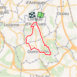
Trail Walking of 9.7 km to be discovered at Auvergne-Rhône-Alpes, Rhône, Civrieux-d'Azergues. This trail is proposed by ANDREJAC.

Description

Départ et retour parking de la mairie. Vers le Besson, la Bergeonnière, Dommartin (le Prost), les Bois Communaux, le Grand Taillis, Chardon Marand, Marand, le Rontet, mairie.

Elevation profile

Positioning

Country:
France
Region :
Auvergne-Rhône-Alpes
Department/Province :
Rhône
Municipality :
Civrieux-d'Azergues
Location:
Unknown
Start:(UTM)
632916 ; 5079749 (31T) N.

Trails nearby

Trail Mountain bike Lozanne - La 5ème Vélozannaise (2014-VTT-45km) - Lozanne - Photo
Mountain bike
tracegps

Mountain bike

Difficult
(1)
Lozanne, Auvergne-Rhône-Alpes, Rhône, France
45 km | 59 km-effort
3h 45min
Yes
Trail Walking Lentilly - Santier des vaches LENTILLY  - Photo
Walking
Arthurjcm

Walking

Very easy
(1)
Lentilly, Auvergne-Rhône-Alpes, Rhône, France
3.2 km | 4.1 km-effort
51min
Yes
Trail Running Limonest - Monts d'Or - Limonest - Photo
Running
tracegps

Running

Medium
(2)
Limonest, Auvergne-Rhône-Alpes, Métropole de Lyon, France
21 km | 32 km-effort
2h 0min
Yes
Trail Horseback riding Chasselay - chasselay florian alain  - Photo
Horseback riding
lau74

Horseback riding

Easy
(1)
Chasselay, Auvergne-Rhône-Alpes, Rhône, France
13.3 km | 17.3 km-effort
2h 16min
Yes
Trail On foot Saint-Jean-des-Vignes - De Bagnols à Lozanne - Photo
On foot
PRO

On foot

Easy
Saint-Jean-des-Vignes, Auvergne-Rhône-Alpes, Rhône, France
4 km | 5 km-effort
1h 7min
No
Trail On foot Lozanne - De Lozanne à Marcy - Photo
On foot
PRO

On foot

Easy
Lozanne, Auvergne-Rhône-Alpes, Rhône, France
12.2 km | 15.6 km-effort
3h 32min
No
Trail Walking Dommartin - A_DOMMARTIN 69380 Civrieux - Marand - Photo
Walking
ANDREJAC

Walking

Easy
(1)
Dommartin, Auvergne-Rhône-Alpes, Rhône, France
10.1 km | 12.2 km-effort
3h 0min
Yes
Trail Walking Saint-Jean-des-Vignes - A_ST JEAN DES VIGNES 69380 Pierre Folle - Fontainebleau - Photo
Walking
ANDREJAC

Walking

Easy
(1)
Saint-Jean-des-Vignes, Auvergne-Rhône-Alpes, Rhône, France
8 km | 11 km-effort
3h 0min
Yes
Trail Walking Morancé - morance - Photo
Walking
6974gros

Walking

Very easy
(1)
Morancé, Auvergne-Rhône-Alpes, Rhône, France
7.9 km | 9.7 km-effort
1h 46min
Yes


Close
My subscriptions