Trail Horseback riding Aspach-Michelbach - Circuit Sundgau - Michelbach - Spechbach le bas - Photo

Circuit Sundgau - Michelbach - Spechbach le bas

Promouvoir le Tourisme Equestre en Alsace GUIDE+

© OpenStreetMap contributors
Length
Length
28 km
Max alt
Max alt
388 m
Uphill gradient
Uphill gradient
420 m
Km-Effort
Km-Effort  
34 km
Min alt
Min alt
262 m
Downhill gradient
Downhill gradient
491 m
Boucle
Boucle
No
Creation date :
2018-04-11 05:12:59.338
Updated on :
2019-04-09 06:17:22.966

(0 Reviews)

Horseback riding
Horseback riding
4h23
Difficulty : Difficult

Scan this QR Code to open this trail in the SityTrail application

FREE GPS app for hiking

Logo SityTrail SityTrail

IGN / Geographical institutes

Download SityTrail from the App Store Download SityTrail from Google Play

Logo SityTrail SityTrail World

The world is yours!

Download SityTrail from the App Store Download SityTrail from Google Play Download SityTrail on Huawei AppGallery

About

Trail Horseback riding of 28 km to be discovered at Grand Est, Haut-Rhin, Aspach-Michelbach. This trail is proposed by Tourisme Equestre Alsace.

Elevation profile

Photos

Positioning

Country:
France
Region :
Grand Est
Department/Province :
Haut-Rhin
Municipality :
Aspach-Michelbach
Location:
Michelbach
Start:(UTM)
358499 ; 5291586 (32T) N.

Trails nearby

Trail Walking Sentheim - Sentheim Rossberg - Photo
Walking
helmut68

Walking

Medium
(1)
Sentheim, Grand Est, Haut-Rhin, France
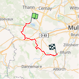
27 km | 40 km-effort
6h 11min
Yes
Trail On foot Sentheim - Sentier géologique du Wolfloch - Photo
On foot
PRO

On foot

Easy
Sentheim, Grand Est, Haut-Rhin, France
3.8 km | 4.8 km-effort
1h 5min
No
Trail Walking Sentheim - Knapphutte Saegenkopf Hütte - Photo
Walking
helmut68

Walking

Medium
Sentheim, Grand Est, Haut-Rhin, France
13.8 km | 17.2 km-effort
5h 11min
Yes
Trail Walking Burnhaupt-le-Haut - Rando du 09/02/2024 par Alain...Pont d'Aspach - Photo
Walking
boubou68

Walking

Very difficult
Burnhaupt-le-Haut, Grand Est, Haut-Rhin, France
22 km | 27 km-effort
5h 12min
Yes
Trail Walking Sentheim - Montori - Photo
Walking
helmut68

Walking

Medium
Sentheim, Grand Est, Haut-Rhin, France
17.7 km | 24 km-effort
4h 47min
Yes
Trail Mountain bike Sentheim - AperoDioller - Photo
Mountain bike
helmut68

Mountain bike

Easy
Sentheim, Grand Est, Haut-Rhin, France
24 km | 27 km-effort
1h 23min
Yes
Trail Walking Sentheim - Baerenkopf  - Photo
Walking
helmut68

Walking

Difficult
Sentheim, Grand Est, Haut-Rhin, France
33 km | 49 km-effort
7h 0min
Yes
Trail Walking Sentheim - Lac Seigneurie Soultzbach - Photo
Walking
helmut68

Walking

Easy
Sentheim, Grand Est, Haut-Rhin, France
10.9 km | 12.7 km-effort
3h 26min
Yes
Trail Walking Sentheim - Sentheim Bellemagny Sentheim  - Photo
Walking
helmut68

Walking

Medium
Sentheim, Grand Est, Haut-Rhin, France
23 km | 28 km-effort
5h 37min
Yes


Close
My subscriptions