


Rando de reprise

raivavae
User
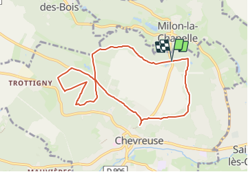

Length
8.5 km

Max alt
178 m

Uphill gradient
95 m
Km-Effort
9.8 km

Min alt
151 m

Downhill gradient
96 m
Boucle
Yes
Creation date :
2023-09-11 11:04:44.941
Updated on :
2023-09-11 11:11:54.436
2h13
Difficulty : Medium

FREE GPS app for hiking
 SityTrail
IGN / Geographical institutes
SityTrail Plus
The world is yours!
About
Trail Walking of 8.5 km to be discovered at Ile-de-France, Yvelines, Chevreuse. This trail is proposed by raivavae.
Positioning
Country:
France
Region :
Ile-de-France
Department/Province :
Yvelines
Municipality :
Chevreuse
Location:
Unknown
Start:(Dec)
Start:(UTM)
430060 ; 5396885 (31U) N.
Comments