


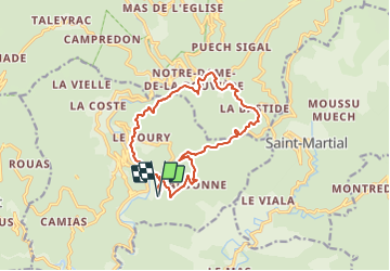
Le Villaret - Valbonne - Notre Dame de Rouvière

GeorgesV.
User

Length
14.8 km

Max alt
606 m

Uphill gradient
636 m
Km-Effort
23 km

Min alt
239 m

Downhill gradient
636 m
Boucle
Yes
Creation date :
2023-10-20 09:46:18.0
Updated on :
2023-10-20 09:46:19.097

FREE GPS app for hiking
 SityTrail
IGN / Geographical institutes
SityTrail Plus
The world is yours!
About
Trail of 14.8 km to be discovered at Occitania, Gard, Saint-André-de-Majencoules. This trail is proposed by GeorgesV..
Description
Vers St André
Positioning
Country:
France
Region :
Occitania
Department/Province :
Gard
Municipality :
Saint-André-de-Majencoules
Location:
Unknown
Start:(Dec)
Start:(UTM)
555151 ; 4874643 (31T) N.
Comments