


Durtol. Sarcenat

Papou63patrick
User
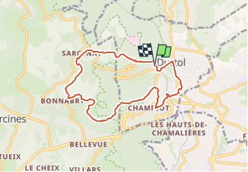

Length
8.2 km

Max alt
764 m

Uphill gradient
279 m
Km-Effort
11.9 km

Min alt
489 m

Downhill gradient
286 m
Boucle
Yes
Creation date :
2023-11-18 12:37:00.428
Updated on :
2023-11-18 14:57:40.468
2h20
Difficulty : Medium

FREE GPS app for hiking
 SityTrail
IGN / Geographical institutes
SityTrail Plus
The world is yours!
About
Trail Walking of 8.2 km to be discovered at Auvergne-Rhône-Alpes, Puy-de-Dôme, Durtol. This trail is proposed by Papou63patrick.
Positioning
Country:
France
Region :
Auvergne-Rhône-Alpes
Department/Province :
Puy-de-Dôme
Municipality :
Durtol
Location:
Unknown
Start:(Dec)
Start:(UTM)
503727 ; 5071215 (31T) N.
Comments