


Verignon les Chapelles

aljac
User
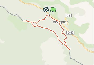

Length
7.8 km

Max alt
1072 m

Uphill gradient
293 m
Km-Effort
11.7 km

Min alt
831 m

Downhill gradient
291 m
Boucle
Yes
Creation date :
2023-12-05 13:14:16.083
Updated on :
2023-12-05 15:54:13.492
2h39
Difficulty : Easy

FREE GPS app for hiking
 SityTrail
IGN / Geographical institutes
SityTrail Plus
The world is yours!
About
Trail Walking of 7.8 km to be discovered at Provence-Alpes-Côte d'Azur, Var, Vérignon. This trail is proposed by aljac.
Positioning
Country:
France
Region :
Provence-Alpes-Côte d'Azur
Department/Province :
Var
Municipality :
Vérignon
Location:
Unknown
Start:(Dec)
Start:(UTM)
279589 ; 4837341 (32T) N.
Comments