Trail Winter sports Montlebon - GTJ Intégrale par Malatrait - Photo

GTJ Intégrale par Malatrait

© OpenStreetMap contributors
Length
Length
184 km
Max alt
Max alt
1408 m
Uphill gradient
Uphill gradient
4051 m
Km-Effort
Km-Effort  
238 km
Min alt
Min alt
907 m
Downhill gradient
Downhill gradient
4046 m
Boucle
Boucle
No
Creation date :
2015-02-21 00:00:00.0
Updated on :
2015-02-21 00:00:00.0

(0 Reviews)

Winter sports
Winter sports
--
Difficulty : Medium

Scan this QR Code to open this trail in the SityTrail application

FREE GPS app for hiking

Logo SityTrail SityTrail

IGN / Geographical institutes

Download SityTrail from the App Store Download SityTrail from Google Play

Logo SityTrail SityTrail World

The world is yours!

Download SityTrail from the App Store Download SityTrail from Google Play Download SityTrail on Huawei AppGallery

About

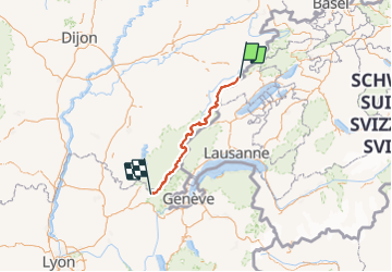
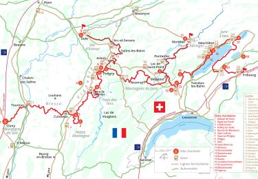
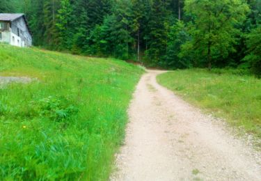
Trail Winter sports of 184 km to be discovered at Bourgogne-Franche-Comté, Doubs, Montlebon. This trail is proposed by FredoDavid.

Elevation profile

Positioning

Country:
France
Region :
Bourgogne-Franche-Comté
Department/Province :
Doubs
Municipality :
Montlebon
Location:
Unknown
Start:(Dec)
Start:(UTM)
322952 ; 5212078 (32T) N.

Trails nearby

Trail On foot Le Locle - Hôtel du Saut du Doubs - Gare des Brenets - Photo
On foot
PRO

On foot

Easy
Le Locle, Neuchâtel, Unknown, Switzerland
3.1 km | 4.3 km-effort
58min
No
Trail On foot Le Locle - Les Frêtes - fixme - Photo
On foot
PRO

On foot

Easy
Le Locle, Neuchâtel, Unknown, Switzerland
4.1 km | 6.7 km-effort
1h 31min
No
Trail On foot Le Locle - Les Frêtes - fixme - Photo
On foot
PRO

On foot

Easy
Le Locle, Neuchâtel, Unknown, Switzerland
3.4 km | 5.8 km-effort
1h 19min
No
Trail Walking Montlebon - montlebon - Photo
Walking
eltonnermou

Walking

Medium
Montlebon, Bourgogne-Franche-Comté, Doubs, France
16.4 km | 23 km-effort
6h 1min
Yes
Trail Walking Morteau - Via Cluny: de Morteau (Montagnes du Jura) à Cluny (Bourgogne) - Photo
Walking
GUIDE
ViaCluny

Walking

Very difficult
Morteau, Bourgogne-Franche-Comté, Doubs, France
445 km | 590 km-effort
134h 8min
No
Trail Bicycle tourism Les Fins - GTJ #2  - Photo
Bicycle tourism
GUIDE
David25400

Bicycle tourism

Difficult
Les Fins, Bourgogne-Franche-Comté, Doubs, France
103 km | 125 km-effort
9h 35min
No
Trail Road bike Villers-le-Lac - VILLERS LE LAC - MORTEAU - PONTARLIER - JOUX - LE LOCLE - VILLERS LE LAC - Photo
Road bike
jean-marie.parachini

Road bike

Medium
Villers-le-Lac, Bourgogne-Franche-Comté, Doubs, France
88 km | 108 km-effort
5h 26min
Yes
Trail Walking  - Montlebon Suisse La Brévine - Photo
Walking
i20

Walking

Medium
, Bourgogne-Franche-Comté, Doubs, France
15.2 km | 22 km-effort
3h 19min
Yes
Trail Walking Le Locle - Marche 2019 - Colo - Photo
Walking
norbertmarteau

Walking

Very easy
Le Locle, Neuchâtel, Unknown, Switzerland
22 km | 34 km-effort
4h 54min
No


Close
My subscriptions