


latrape par le soleil fait 2024

pidjam
User
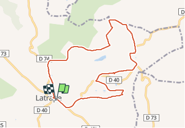

Length
10.4 km

Max alt
368 m

Uphill gradient
256 m
Km-Effort
13.8 km

Min alt
240 m

Downhill gradient
258 m
Boucle
Yes
Creation date :
2024-01-14 13:10:19.338
Updated on :
2024-01-14 15:41:54.426
2h23
Difficulty : Easy

FREE GPS app for hiking
 SityTrail
IGN / Geographical institutes
SityTrail Plus
The world is yours!
About
Trail Walking of 10.4 km to be discovered at Occitania, Haute-Garonne, Latrape. This trail is proposed by pidjam.
Positioning
Country:
France
Region :
Occitania
Department/Province :
Haute-Garonne
Municipality :
Latrape
Location:
Unknown
Start:(Dec)
Start:(UTM)
361161 ; 4789383 (31T) N.
Comments