


pflixbourg et hohlandsbourg

OxygenLT
User
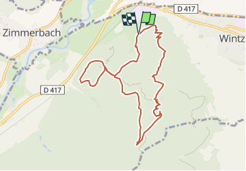

Length
8.9 km

Max alt
629 m

Uphill gradient
457 m
Km-Effort
15 km

Min alt
274 m

Downhill gradient
450 m
Boucle
Yes
Creation date :
2024-02-23 13:47:43.438
Updated on :
2024-03-06 08:09:54.831
3h23
Difficulty : Difficult

FREE GPS app for hiking
 SityTrail
IGN / Geographical institutes
SityTrail Plus
The world is yours!
About
Trail Walking of 8.9 km to be discovered at Grand Est, Haut-Rhin, Wintzenheim. This trail is proposed by OxygenLT.
Positioning
Country:
France
Region :
Grand Est
Department/Province :
Haut-Rhin
Municipality :
Wintzenheim
Location:
Unknown
Start:(Dec)
Start:(UTM)
370735 ; 5325896 (32U) N.
Comments