Trail Walking La Roche-sur-Foron - tentative de Balme - Photo
 tjrp_fr
tjrp_fr

User

© OpenStreetMap contributors
Length
Length
6.2 km
Max alt
Max alt
1528 m
Uphill gradient
Uphill gradient
363 m
Km-Effort
Km-Effort  
11.1 km
Min alt
Min alt
1171 m
Downhill gradient
Downhill gradient
368 m
Boucle
Boucle
Yes
Creation date :
2015-03-24 00:00:00.0
Updated on :
2015-03-24 00:00:00.0

(0 Reviews)

Walking
Walking
2h12
Difficulty : Easy

Scan this QR Code to open this trail in the SityTrail application

FREE GPS app for hiking

Logo SityTrail SityTrail

IGN / Geographical institutes

Download SityTrail from the App Store Download SityTrail from Google Play

Logo SityTrail SityTrail World

The world is yours!

Download SityTrail from the App Store Download SityTrail from Google Play Download SityTrail on Huawei AppGallery

About

Trail Walking of 6.2 km to be discovered at Auvergne-Rhône-Alpes, Upper Savoy, La Roche-sur-Foron. This trail is proposed by tjrp_fr.

Description

montée jusqu'au dessus du chalet de Balme, mais traversée jusqu'au chalet impossible sans raquettes, alors demi-tout

Elevation profile

Positioning

Country:
France
Region :
Auvergne-Rhône-Alpes
Department/Province :
Upper Savoy
Municipality :
La Roche-sur-Foron
Location:
Unknown
Start:(UTM)
292840 ; 5099927 (32T) N.

Trails nearby

Trail Walking Fillière - 12-06-2022 Col de l'Enclave  - Photo
Walking
GUIDE
Kargil

Walking

Medium
Fillière, Auvergne-Rhône-Alpes, Upper Savoy, France
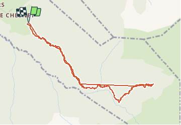
11.8 km | 24 km-effort
3h 42min
Yes
Trail Walking La Roche-sur-Foron - Tour de Sur Cou - Photo
Walking
christophe7406

Walking

Medium
(1)
La Roche-sur-Foron, Auvergne-Rhône-Alpes, Upper Savoy, France
6.9 km | 15.1 km-effort
3h 0min
Yes
Trail Walking La Roche-sur-Foron - sur cou - Photo
Walking
alexdigit

Walking

Easy
(1)
La Roche-sur-Foron, Auvergne-Rhône-Alpes, Upper Savoy, France
3.4 km | 7.8 km-effort
1h 19min
No
Trail Walking La Roche-sur-Foron - GLIERES / BORNES: COL DU COU - CHALET DE BALME - Photo
Walking
djeepee74

Walking

Easy
La Roche-sur-Foron, Auvergne-Rhône-Alpes, Upper Savoy, France
7.1 km | 13 km-effort
3h 2min
Yes
Trail Walking La Roche-sur-Foron - 74 roche parnal 05.08.2022 - Photo
Walking
himba26100

Walking

Medium
La Roche-sur-Foron, Auvergne-Rhône-Alpes, Upper Savoy, France
9.5 km | 20 km-effort
6h 23min
Yes
Trail Walking La Roche-sur-Foron - 2021-09-22_09h20m43_activity_7510877141 - Photo
Walking
djeepee74

Walking

Very difficult
La Roche-sur-Foron, Auvergne-Rhône-Alpes, Upper Savoy, France
12 km | 24 km-effort
5h 33min
Yes
Trail Walking Fillière - Sous-Dines Par Le Monthieu 12-06-2021 - Photo
Walking
GUIDE
Kargil

Walking

Medium
Fillière, Auvergne-Rhône-Alpes, Upper Savoy, France
11.2 km | 23 km-effort
3h 46min
Yes
Trail Walking La Roche-sur-Foron - GLIERES / BORNES: LE CHENET - SUR COU - COL DU FREU - ROCHE PARNAL - COL DU CABLE - BALME - Photo
Walking
djeepee74

Walking

Difficult
La Roche-sur-Foron, Auvergne-Rhône-Alpes, Upper Savoy, France
10.4 km | 23 km-effort
5h 15min
Yes
Trail Walking Saint-Laurent - Moussy - Le Pacheux - Passage de la Cache - Photo
Walking
GUIDE
Kargil

Walking

Medium
Saint-Laurent, Auvergne-Rhône-Alpes, Upper Savoy, France
10.4 km | 21 km-effort
3h 35min
Yes


Close
My subscriptions