


grasse_digne_oct2023

aeldin
User
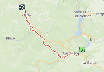

Length
20 km

Max alt
1253 m

Uphill gradient
801 m
Km-Effort
31 km

Min alt
713 m

Downhill gradient
757 m
Boucle
No
Creation date :
2024-04-23 17:30:33.088
Updated on :
2024-09-16 13:03:44.948
0m
Difficulty : Very easy

FREE GPS app for hiking
 SityTrail
IGN / Geographical institutes
SityTrail Plus
The world is yours!
About
Trail Equestrian of 20 km to be discovered at Provence-Alpes-Côte d'Azur, Alpes-de-Haute-Provence, Castellane. This trail is proposed by aeldin.

Positioning
Country:
France
Region :
Provence-Alpes-Côte d'Azur
Department/Province :
Alpes-de-Haute-Provence
Municipality :
Castellane
Location:
Unknown
Start:(Dec)
Start:(UTM)
301442 ; 4857220 (32T) N.
Comments