


Comigne fait 2024

pidjam
User

Length
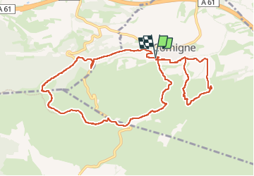
12.8 km

Max alt
358 m

Uphill gradient
394 m
Km-Effort
18.1 km

Min alt
115 m

Downhill gradient
393 m
Boucle
Yes
Creation date :
2024-05-16 07:32:06.116
Updated on :
2024-05-16 12:35:04.084
3h27
Difficulty : Medium

FREE GPS app for hiking
 SityTrail
IGN / Geographical institutes
SityTrail Plus
The world is yours!
About
Trail Walking of 12.8 km to be discovered at Occitania, Aude, Comigne. This trail is proposed by pidjam.
Positioning
Country:
France
Region :
Occitania
Department/Province :
Aude
Municipality :
Comigne
Location:
Unknown
Start:(Dec)
Start:(UTM)
465591 ; 4779633 (31T) N.
Comments