Trail Walking Saint-Hubert - RF-Lu-11 - Raccourci - Dans les forêts où le cerf est roi ! Fourneau Saint-Michel - Photo

RF-Lu-11 - Raccourci - Dans les forêts où le cerf est roi ! Fourneau Saint-Michel

Randonnez sur et autour des GR ® wallons (Sentiers de Grande Randonnée). PRO

© OpenStreetMap contributors
Length
Length
10.6 km
Max alt
Max alt
526 m
Uphill gradient
Uphill gradient
251 m
Km-Effort
Km-Effort  
13.9 km
Min alt
Min alt
294 m
Downhill gradient
Downhill gradient
250 m
Boucle
Boucle
Yes
Creation date :
2019-08-07 07:22:09.758
Updated on :
2022-01-15 13:24:17.102

(2 Reviews)

Walking
Walking
2h58
Difficulty : Unknown

Scan this QR Code to open this trail in the SityTrail application

FREE GPS app for hiking

Logo SityTrail SityTrail

IGN / Geographical institutes

Download SityTrail from the App Store Download SityTrail from Google Play

Logo SityTrail SityTrail World

The world is yours!

Download SityTrail from the App Store Download SityTrail from Google Play Download SityTrail on Huawei AppGallery

About

Trail Walking of 10.6 km to be discovered at Wallonia, Luxembourg, Saint-Hubert. This trail is proposed by GR Rando.

Description

Raccourci - Dans les forêts où le cerf est roi ! Fourneau Saint-Michel.
Dans quel type de paysage randonnons-nous ?
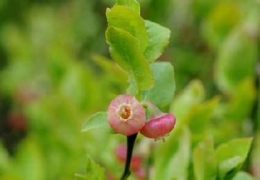
De splendides parcours en forêt !
Où démarrons-nous ?
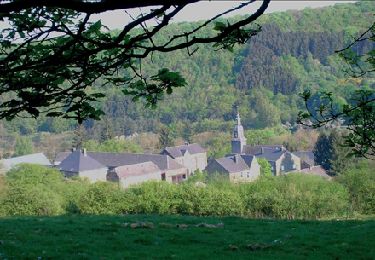
À l’entrée du « musée de la Vie rurale » du Fourneau Saint-Michel (carte Michelin n° 534, pli R/22), non loin du village d’Awenne (carte Michelin n° 534, pli Q/22).
Comment y arriver ?
De Saint-Hubert ou de Masbourg, la N849 nous conduit au Fourneau Saint-Michel. Juste avant (en venant de Masbourg) ou juste après (en venant de Saint-Hubert) les grands parkings des musées, prendre la direction « Awenne, 4 » pour arriver, 150 mètres plus loin, au petit « parking 2 », situé en face de l’entrée du musée de la Vie rurale, le point de départ de la balade.
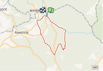
Combien de kilomètres ?
15,1 km ou, en raccourcissant la rando, 10,7 km.
Quelle difficulté ?
Aucune.
Sur quel GR randonnons-nous ?
Cette boucle nous fait suivre un tronçon commun au GR 14 « Sentier de l’Ardenne – Malmedy-Bouillon-Sedan » et au GR 151, puis, après des kilomètres hors GR, un autre morceau du GR 14.
Quelle est la carte IGN de référence ?
Carte IGN au 1:20 000, 59/7-8, « Tellin - Saint-Hubert ».
Que découvrons-nous aujourd’hui ?
Le « musée de la Vie rurale » et « le musée du Fer et de la Métallurgie », tous deux au Founeau Saint-Michel, à quelques centaines de mètres l’un de l’autre.
Non loin de là, à Ambly, l’« Élevage de la Pépinette » vous propose des promenades nature en attelage à travers campagne et forêt.
Transports en commun ?
Aucune possibilité.

Points of interest

Point of interest Saint-Hubert - Arbres remarquables - Photo
GR Rando
SAINT-HUBERT 
Point of interest Saint-Hubert - l’arboretum de Saint-Michel - Photo
GR Rando
Point of interest Saint-Hubert - Fourneau Saint-Michel - Photo
GR Rando
SAINT-HUBERT 
Point of interest Saint-Hubert - Unnamed POI - Photo
GR Rando
SAINT-HUBERT 
Point of interest Saint-Hubert - CRIE du Fourneau Saint-Michel - Photo
GR Rando

Positioning

Country:
Belgium
Region :
Wallonia
Department/Province :
Luxembourg
Municipality :
Saint-Hubert
Location:
Unknown
Start:(UTM)
667157 ; 5550856 (31U) N.

Comments

Please log in to post a review or rate the element


Trails nearby

Trail Walking Saint-Hubert - Saint-Hubert - Les Abanages (SH03) - Photo
Walking
GUIDE+

Walking

Difficult
(11)
Saint-Hubert, Wallonia, Luxembourg, Belgium
9.8 km | 13.1 km-effort
2h 49min
Yes
Trail Walking Tellin - GG-Lu-13_Grupont - Poix-Saint-Hubert - Photo
Walking
PRO

Walking

Very difficult
(2)
Tellin, Wallonia, Luxembourg, Belgium
26 km | 34 km-effort
7h 23min
No
Trail Walking Tellin - Balade à Grupont - Photo
Walking
GUIDE
Desrumaux

Walking

Easy
(1)
Tellin, Wallonia, Luxembourg, Belgium
8.4 km | 11.9 km-effort
2h 33min
Yes
Trail Walking Tellin - Grupont - Promenade du Bois du Machi (EN) - Photo
Walking
GUIDE+

Walking

Medium
(1)
Tellin, Wallonia, Luxembourg, Belgium
8.6 km | 12.6 km-effort
2h 37min
Yes
Trail Mountain bike Nassogne - Nassogne - Circuit VTT rouge 4 - Photo
Mountain bike
GUIDE+

Mountain bike

Difficult
(1)
Nassogne, Wallonia, Luxembourg, Belgium
26 km | 36 km-effort
2h 16min
Yes
Trail Walking Saint-Hubert - Saint-Hubert - Circuit Natura 2000, des sites qui valent le détour - Lx16 - Photo
Walking
GUIDE+

Walking

Medium
(3)
Saint-Hubert, Wallonia, Luxembourg, Belgium
9.8 km | 13 km-effort
1h 11min
Yes
Trail Walking Nassogne - RB-LUX-07- Raccourci - En musardant entre Lhomme et Masblette, entre ri de Warlet et ruisseau de l’Hinson - Photo
Walking
PRO

Walking

Medium
(3)
Nassogne, Wallonia, Luxembourg, Belgium
20 km | 29 km-effort
6h 0min
Yes
Trail Cycle Nassogne - Massif de Nassogne - Photo
Cycle
GUIDE+

Cycle

Medium
(2)
Nassogne, Wallonia, Luxembourg, Belgium
14.2 km | 19 km-effort
1h 4min
Yes
Trail Cycle Nassogne - Massif de Nassogne : variante 1 - Photo
Cycle
GUIDE+

Cycle

Medium
(1)
Nassogne, Wallonia, Luxembourg, Belgium
6.4 km | 8.1 km-effort
27min
Yes


Close
My subscriptions