


ESTAING

PascalBanide
User
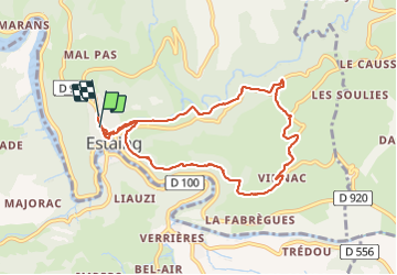

Length
9.1 km

Max alt
499 m

Uphill gradient
274 m
Km-Effort
12.8 km

Min alt
319 m

Downhill gradient
269 m
Boucle
Yes
Creation date :
2015-04-14 00:00:00.0
Updated on :
2015-04-14 00:00:00.0
2h39
Difficulty : Easy

FREE GPS app for hiking
 SityTrail
IGN / Geographical institutes
SityTrail Plus
The world is yours!
About
Trail Other activity of 9.1 km to be discovered at Occitania, Aveyron, Estaing. This trail is proposed by PascalBanide.
Positioning
Country:
France
Region :
Occitania
Department/Province :
Aveyron
Municipality :
Estaing
Location:
Unknown
Start:(Dec)
Start:(UTM)
473886 ; 4933629 (31T) N.
Comments