Trail Walking El Paso - La Palma-Route des Volcans-GR131-3 - Photo

La Palma-Route des Volcans-GR131-3

© OpenStreetMap contributors
Length
Length
24 km
Max alt
Max alt
1927 m
Uphill gradient
Uphill gradient
668 m
Km-Effort
Km-Effort  
37 km
Min alt
Min alt
15 m
Downhill gradient
Downhill gradient
2107 m
Boucle
Boucle
No
Creation date :
2016-03-09 00:00:00.0
Updated on :
2016-03-09 00:00:00.0

(0 Reviews)

Walking
Walking
7h03
Difficulty : Medium

Scan this QR Code to open this trail in the SityTrail application

FREE GPS app for hiking

Logo SityTrail SityTrail

IGN / Geographical institutes

Download SityTrail from the App Store Download SityTrail from Google Play

Logo SityTrail SityTrail World

The world is yours!

Download SityTrail from the App Store Download SityTrail from Google Play Download SityTrail on Huawei AppGallery

About

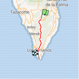
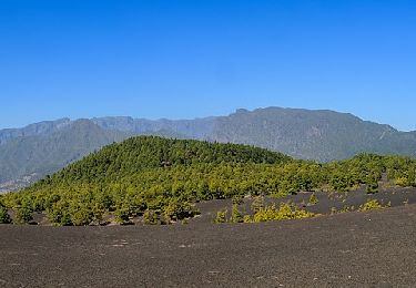
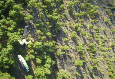
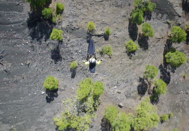
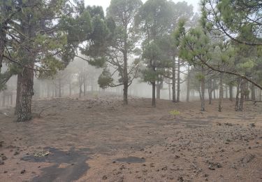
Trail Walking of 24 km to be discovered at Canary Islands, Santa Cruz de Tenerife, El Paso. This trail is proposed by fredetpascale.

Elevation profile

Points of interest

Point of interest Fuencaliente de la Palma - Bar Parada - Photo
fredetpascale
FUENCALIENTE DE LA PALMA 
Point of interest Fuencaliente de la Palma - Tasca El Fog?n - Photo
fredetpascale
FUENCALIENTE DE LA PALMA 
Point of interest Fuencaliente de la Palma - Canal del Estado - Photo
fredetpascale
FUENCALIENTE DE LA PALMA 
Point of interest El Paso - Campo de lavas del Duraznero - Photo
fredetpascale
Point of interest El Paso - Monta?a del Gallo - Photo
fredetpascale
Point of interest El Paso - Hoyo Negro (erupci?n del Volc?n de San Juan) - Photo
fredetpascale
Point of interest Fuencaliente de la Palma - Llano de los Guanches - Photo
fredetpascale
FUENCALIENTE DE LA PALMA 
Point of interest Villa de Mazo - Mirador natural hacia Las Deseadas - Photo
fredetpascale
Point of interest El Paso - Mirador sobre el Llano de los Jables, desde las laderas del Birigoyo - Photo
fredetpascale
Point of interest Fuencaliente de la Palma - Mirador sobre el Volc?n de Tigalate o Volc?n de Mart?n (1646) - Photo
fredetpascale
FUENCALIENTE DE LA PALMA 
Point of interest El Paso - Balc?n natural hacia La Caldera - Photo
fredetpascale
Point of interest Fuencaliente de la Palma - Iglesia de San Antonio Abad (BIC) - Photo
fredetpascale
FUENCALIENTE DE LA PALMA 
Point of interest Fuencaliente de la Palma - Bar Restaurante Imperial - Photo
fredetpascale
FUENCALIENTE DE LA PALMA 
Point of interest Fuencaliente de la Palma - Salinas de Fuencaliente (Sitio de Inter?s Cient?fico) - Photo
fredetpascale
FUENCALIENTE DE LA PALMA 
Point of interest  - Roque Tenegu?a (BIC) - Photo
fredetpascale
Point of interest Fuencaliente de la Palma - Mirador hacia la Playa de Echentive o Playa Nueva - Photo
fredetpascale
FUENCALIENTE DE LA PALMA 
Point of interest Fuencaliente de la Palma - Vinagreras (Rumex lunaria), una de las primeras especies colonizadoras de las coladas volc?nicas - Photo
fredetpascale
FUENCALIENTE DE LA PALMA 
Point of interest Fuencaliente de la Palma - Centro de Visitantes del San Antonio - Photo
fredetpascale
FUENCALIENTE DE LA PALMA 
Point of interest Fuencaliente de la Palma - Faro de Fuencaliente (Centro de Interpretaci?n de la Reserva Marina) - Photo
fredetpascale
FUENCALIENTE DE LA PALMA 
Point of interest Villa de Mazo - Dep?sito de agua potable, recargado peri?dicamente mediante cubas. - Photo
fredetpascale
Point of interest Fuencaliente de la Palma - Desv?o hacia el ?rea Recreativa de Fuente de Los Roques - Photo
fredetpascale
FUENCALIENTE DE LA PALMA 
Point of interest Fuencaliente de la Palma - Volc?n de Tigalate o Volc?n Mart?n - Photo
fredetpascale
FUENCALIENTE DE LA PALMA 
Point of interest Fuencaliente de la Palma - Supermercado - Photo
fredetpascale
FUENCALIENTE DE LA PALMA 
Point of interest Fuencaliente de la Palma - Bar Parrilla Junonia - Photo
fredetpascale
FUENCALIENTE DE LA PALMA 

Positioning

Country:
Spain
Region :
Canary Islands
Department/Province :
Santa Cruz de Tenerife
Municipality :
El Paso
Location:
Unknown
Start:(UTM)
222642 ; 3168522 (28R) N.

Trails nearby

Trail On foot Villa de Mazo - SL LP 123 - Photo
On foot
PRO

On foot

Easy
Villa de Mazo, Canary Islands, Santa Cruz de Tenerife, Spain
3.4 km | 4.6 km-effort
1h 3min
No
Trail On foot El Paso - SL LP 105 Coladas de San Juan-Camino Barquito - Photo
On foot
PRO

On foot

Easy
El Paso, Canary Islands, Santa Cruz de Tenerife, Spain
3.4 km | 5 km-effort
1h 8min
No
Trail On foot El Paso - SL LP 103 Coladas de San Juan-Llano de Jable - Photo
On foot
PRO

On foot

Easy
El Paso, Canary Islands, Santa Cruz de Tenerife, Spain
4 km | 5.3 km-effort
1h 12min
No
Trail On foot El Paso - SL LP 101 Tacande - Llanos del Jable - Photo
On foot
PRO

On foot

Easy
El Paso, Canary Islands, Santa Cruz de Tenerife, Spain
4.2 km | 9.6 km-effort
2h 10min
No
Trail On foot El Paso - SL LP 100 Tacande - Pista de Piedras Blancas - Photo
On foot
PRO

On foot

Easy
El Paso, Canary Islands, Santa Cruz de Tenerife, Spain
3.5 km | 5.9 km-effort
1h 20min
No
Trail On foot El Paso - SL LP 107 San Nicolás-Hoyo de La Sima - Photo
On foot
PRO

On foot

Easy
El Paso, Canary Islands, Santa Cruz de Tenerife, Spain
3.2 km | 5.2 km-effort
1h 11min
No
Trail On foot Villa de Mazo - SL VM 125 Llano de las Moscas-Pico Nambroque - Photo
On foot
PRO

On foot

Easy
Villa de Mazo, Canary Islands, Santa Cruz de Tenerife, Spain
4.5 km | 6.2 km-effort
1h 24min
No
Trail Walking El Paso - Wikiloc - La Palma: Cumbre Vieja Vulkaanroute half - Photo
Walking
GUIDE
Peter.vdbergh

Walking

Very difficult
El Paso, Canary Islands, Santa Cruz de Tenerife, Spain
13.8 km | 24 km-effort
9h 1min
Yes
Trail Walking El Paso - dag 3 La Palma  - Photo
Walking
Geert H.

Walking

Very difficult
El Paso, Canary Islands, Santa Cruz de Tenerife, Spain
19.4 km | 31 km-effort
4h 38min
No


Close
My subscriptions