Trail Other activity Courmayeur - Tour des Gdes Jorasses 7 - Photo

Tour des Gdes Jorasses 7

 srdt29
srdt29

User

© OpenStreetMap contributors
Length
Length
15 km
Max alt
Max alt
3406 m
Uphill gradient
Uphill gradient
301 m
Km-Effort
Km-Effort  
24 km
Min alt
Min alt
1725 m
Downhill gradient
Downhill gradient
1739 m
Boucle
Boucle
No
Creation date :
2019-01-29 19:37:04.107
Updated on :
2020-07-30 18:04:14.448

(0 Reviews)

Other activity
Other activity
3h40
Difficulty : Easy

Scan this QR Code to open this trail in the SityTrail application

FREE GPS app for hiking

Logo SityTrail SityTrail

IGN / Geographical institutes

Download SityTrail from the App Store Download SityTrail from Google Play

Logo SityTrail SityTrail World

The world is yours!

Download SityTrail from the App Store Download SityTrail from Google Play Download SityTrail on Huawei AppGallery

About

Trail Other activity of 15 km to be discovered at Aosta Valley, Unknown, Courmayeur. This trail is proposed by srdt29.

Description

6ème jour - Ski de randonnée- Descente Vallée Blanche

Elevation profile

Positioning

Country:
Italy
Region :
Aosta Valley
Department/Province :
Unknown
Municipality :
Courmayeur
Location:
Unknown
Start:(UTM)
339572 ; 5078896 (32T) N.

Trails nearby

Trail Other activity Chamonix-Mont-Blanc - vallée blanche - Photo
Other activity
jnpollet

Other activity

Difficult
(1)
Chamonix-Mont-Blanc, Auvergne-Rhône-Alpes, Upper Savoy, France
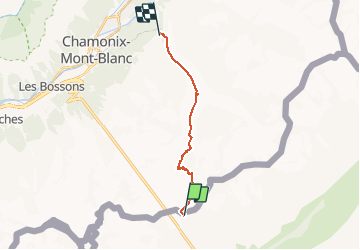
19.8 km | 30 km-effort
3h 21min
No
Trail Walking Courmayeur - étape monte Bianco mottets - Photo
Walking
Bernadette Noirant

Walking

Difficult
Courmayeur, Aosta Valley, Unknown, Italy
21 km | 38 km-effort
8h 17min
No
Trail Walking Courmayeur - TMB J5 Ref. BIANCO - LES MOTTETS - Photo
Walking
GerardBouche

Walking

Difficult
Courmayeur, Aosta Valley, Unknown, Italy
20 km | 38 km-effort
7h 49min
No
Trail Other activity Chamonix-Mont-Blanc - arête des cosmique - Photo
Other activity
bellouelo46

Other activity

Difficult
Chamonix-Mont-Blanc, Auvergne-Rhône-Alpes, Upper Savoy, France
4.1 km | 8.1 km-effort
7h 49min
No
Trail Walking Courmayeur - TMB - Etape 5 - Photo
Walking
maxime.ranchin@aliceadsl.fr

Walking

Difficult
(1)
Courmayeur, Aosta Valley, Unknown, Italy
16.5 km | 34 km-effort
6h 47min
No
Trail Touring skiing Chamonix-Mont-Blanc - refuge des grands mulets  - Photo
Touring skiing
Michel Jovet

Touring skiing

Very easy
Chamonix-Mont-Blanc, Auvergne-Rhône-Alpes, Upper Savoy, France
5.3 km | 13.1 km-effort
3h 9min
No
Trail sport Chamonix-Mont-Blanc - SityTrail - Vallée Blanche - Chamonix - Photo
sport
michel90

sport

Very easy
Chamonix-Mont-Blanc, Auvergne-Rhône-Alpes, Upper Savoy, France
15.1 km | 21 km-effort
Unknown
No
Trail Alpine skiing Chamonix-Mont-Blanc - suuntoapp-SkiTouring-2018-01-28T08-28-00Z-track - Photo
Alpine skiing
Myrostates

Alpine skiing

Difficult
Chamonix-Mont-Blanc, Auvergne-Rhône-Alpes, Upper Savoy, France
23 km | 33 km-effort
4h 6min
No
Trail Other activity Chamonix-Mont-Blanc - Brèche de Puiseux - Photo
Other activity
loicthev

Other activity

Very easy
Chamonix-Mont-Blanc, Auvergne-Rhône-Alpes, Upper Savoy, France
21 km | 40 km-effort
7h 10min
No


Close
My subscriptions