


St Clement CAF

bstebe
User
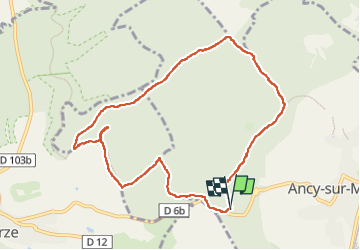

Length
9.1 km

Max alt
368 m

Uphill gradient
201 m
Km-Effort
11.7 km

Min alt
226 m

Downhill gradient
200 m
Boucle
Yes
Creation date :
2024-12-04 12:21:33.725
Updated on :
2024-12-04 15:43:41.738
3h21
Difficulty : Medium

FREE GPS app for hiking
 SityTrail
IGN / Geographical institutes
SityTrail Plus
The world is yours!
About
Trail Walking of 9.1 km to be discovered at Grand Est, Moselle, Ancy-Dornot. This trail is proposed by bstebe.
Positioning
Country:
France
Region :
Grand Est
Department/Province :
Moselle
Municipality :
Ancy-Dornot
Location:
Unknown
Start:(Dec)
Start:(UTM)
283655 ; 5437722 (32U) N.
Comments