


Montpezat - Chalias

Rudy07
User
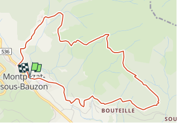

Length
6.4 km

Max alt
813 m

Uphill gradient
291 m
Km-Effort
10.3 km

Min alt
520 m

Downhill gradient
298 m
Boucle
Yes
Creation date :
2024-12-21 09:28:22.741
Updated on :
2025-01-29 19:03:16.066
2h19
Difficulty : Medium

FREE GPS app for hiking
 SityTrail
IGN / Geographical institutes
SityTrail Plus
The world is yours!
About
Trail Walking of 6.4 km to be discovered at Auvergne-Rhône-Alpes, Ardèche, Montpezat-sous-Bauzon. This trail is proposed by Rudy07.
Positioning
Country:
France
Region :
Auvergne-Rhône-Alpes
Department/Province :
Ardèche
Municipality :
Montpezat-sous-Bauzon
Location:
Unknown
Start:(Dec)
Start:(UTM)
595709 ; 4951597 (31T) N.
Comments