Trail Walking Orsières - Cabane de Saleinaz - Photo
 verbier
verbier

User

© OpenStreetMap contributors
Length
Length
7.1 km
Max alt
Max alt
2684 m
Uphill gradient
Uphill gradient
1534 m
Km-Effort
Km-Effort  
22 km
Min alt
Min alt
1139 m
Downhill gradient
Downhill gradient
1 m
Boucle
Boucle
No
Creation date :
2014-12-10 00:00:00.0
Updated on :
2014-12-10 00:00:00.0

(0 Reviews)

Walking
Walking
3h40
Difficulty : Unknown

Scan this QR Code to open this trail in the SityTrail application

FREE GPS app for hiking

Logo SityTrail SityTrail

IGN / Geographical institutes

Download SityTrail from the App Store Download SityTrail from Google Play

Logo SityTrail SityTrail World

The world is yours!

Download SityTrail from the App Store Download SityTrail from Google Play Download SityTrail on Huawei AppGallery

About

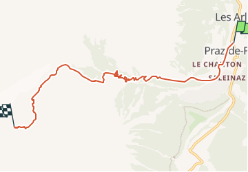
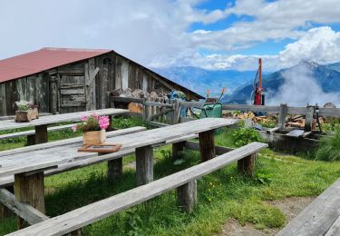
Trail Walking of 7.1 km to be discovered at Valais/Wallis, Entremont, Orsières. This trail is proposed by verbier.

Description

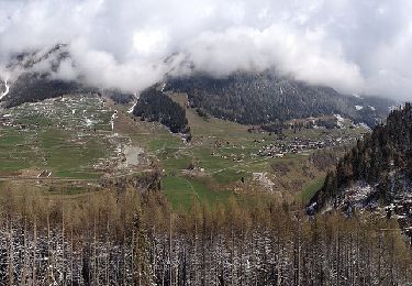
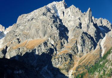
From the water supply point of Saleinaz, cross the river, then take the path in the forest. Sections with mountain ranges and ladders, then winding mountain path with a difficult ascent, to the Saleinaz hut.
About 4 hours from the water supply point. One more hour from Praz-de-Fort.

Elevation profile

Points of interest

Point of interest Orsières - Cabane de Saleinaz - Photo
verbier
Point of interest Orsières - Prise d'eau de Saleinaz - Photo
verbier

Positioning

Country:
Switzerland
Region :
Valais/Wallis
Department/Province :
Entremont
Municipality :
Orsières
Location:
Unknown
Start:(UTM)
354804 ; 5094730 (32T) N.

Trails nearby

Trail On foot Liddes - Chemins pédestre, commune de Liddes - Photo
On foot
PRO

On foot

Easy
Liddes, Valais/Wallis, Entremont, Switzerland
4.3 km | 6.4 km-effort
1h 27min
No
Trail On foot Orsières - sentier du Devin - Photo
On foot
PRO

On foot

Easy
Orsières, Valais/Wallis, Entremont, Switzerland
3.9 km | 6.7 km-effort
1h 31min
Yes
Trail On foot Orsières - Raccard du blé - Photo
On foot
PRO

On foot

Easy
Orsières, Valais/Wallis, Entremont, Switzerland
7.9 km | 13.7 km-effort
3h 6min
Yes
Trail Walking Orsières - TMB 08 - Relais d'Arpette -> Trient - Photo
Walking
uru2010

Walking

Difficult
Orsières, Valais/Wallis, Entremont, Switzerland
17 km | 28 km-effort
6h 39min
No
Trail Snowshoes Orsières - Champex Lac - La Breya - Champex Lac - Photo
Snowshoes
jpksenicz

Snowshoes

Medium
Orsières, Valais/Wallis, Entremont, Switzerland
8.8 km | 18.2 km-effort
3h 1min
Yes
Trail Walking Orsières - CMX ZRMT Étape 2 Champex Cabane de Mille  - Photo
Walking
jeff2

Walking

Medium
Orsières, Valais/Wallis, Entremont, Switzerland
17.9 km | 38 km-effort
7h 15min
No
Trail Walking Orsières - TMB day 5 - Photo
Walking
elixpomatia

Walking

Medium
Orsières, Valais/Wallis, Entremont, Switzerland
16.7 km | 28 km-effort
6h 15min
No
Trail Snowshoes Orsières - Champex Lac - Belvédère - Champex Lac - Photo
Snowshoes
jpksenicz

Snowshoes

Medium
Orsières, Valais/Wallis, Entremont, Switzerland
8.4 km | 13.6 km-effort
2h 52min
Yes
Trail Snowshoes Orsières - Champex Lac - Arpette - Champex Lac - Photo
Snowshoes
jpksenicz

Snowshoes

Easy
Orsières, Valais/Wallis, Entremont, Switzerland
5.8 km | 8.1 km-effort
2h 9min
Yes


Close
My subscriptions