Trail Other activity Marly - 400/Corbaroche/Grotte de Sâles-Chésalles/M - Photo

400/Corbaroche/Grotte de Sâles-Chésalles/M

© OpenStreetMap contributors
Length
Length
10.6 km
Max alt
Max alt
703 m
Uphill gradient
Uphill gradient
213 m
Km-Effort
Km-Effort  
13.4 km
Min alt
Min alt
587 m
Downhill gradient
Downhill gradient
213 m
Boucle
Boucle
Yes
Creation date :
2014-12-10 00:00:00.0
Updated on :
2014-12-10 00:00:00.0

(0 Reviews)

Other activity
Other activity
--
Difficulty : Unknown

Scan this QR Code to open this trail in the SityTrail application

FREE GPS app for hiking

Logo SityTrail SityTrail

IGN / Geographical institutes

Download SityTrail from the App Store Download SityTrail from Google Play

Logo SityTrail SityTrail World

The world is yours!

Download SityTrail from the App Store Download SityTrail from Google Play Download SityTrail on Huawei AppGallery

About

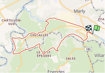
Trail Other activity of 10.6 km to be discovered at Fribourg, Sarine District, Marly. This trail is proposed by nordicmarly.

Description

Parking Stade Gérine
Ancienne Crausa
Réservoir d''eau
Grotte de Sâles
Observatoire
Forêt de Monteynan
A l''entrée de la fôrêt dir. Hauterive, prendre à droite et descendre dir.la gravière
Contourner la gravière
Remonter vers Chésalles
Chésalles
Le Petit-Bugnon
La Vernaie
Remonter la Gérine

Elevation profile

Positioning

Country:
Switzerland
Region :
Fribourg
Department/Province :
Sarine District
Municipality :
Marly
Location:
Unknown
Start:(UTM)
360087 ; 5181154 (32T) N.

Trails nearby

Trail On foot Villars-sur-Glâne - Tour des trois rivières - Photo
On foot
PRO

On foot

Easy
Villars-sur-Glâne, Fribourg, Sarine District, Switzerland
5.1 km | 7.1 km-effort
1h 36min
No
Trail On foot Hauterive (FR) - Circuit Hauterive - Photo
On foot
PRO

On foot

Easy
Hauterive (FR), Fribourg, Sarine District, Switzerland
5 km | 6.7 km-effort
1h 31min
No
Trail On foot Hauterive (FR) - Hauterive - La Tuffière - Photo
On foot
PRO

On foot

Easy
Hauterive (FR), Fribourg, Sarine District, Switzerland
5 km | 6.6 km-effort
1h 30min
No
Trail On foot Hauterive (FR) - Circuit de La Tuffière - Photo
On foot
PRO

On foot

Easy
Hauterive (FR), Fribourg, Sarine District, Switzerland
6.2 km | 8.2 km-effort
1h 52min
No
Trail On foot Hauterive (FR) - Grangeneuve - La Tuffière - Photo
On foot
PRO

On foot

Easy
Hauterive (FR), Fribourg, Sarine District, Switzerland
5 km | 6.6 km-effort
1h 29min
No
Trail On foot Fribourg - Freiburg - Bourguillon - Schürmatt - Photo
On foot
PRO

On foot

Easy
Fribourg - Freiburg, Fribourg, Sarine District, Switzerland
3.9 km | 5.5 km-effort
1h 14min
No
Trail On foot Fribourg - Freiburg - Freiburg - Fribourg (Jura) - Photo
On foot
PRO

On foot

Easy
Fribourg - Freiburg, Fribourg, Sarine District, Switzerland
3.8 km | 5.5 km-effort
1h 15min
No
Trail On foot Fribourg - Freiburg - Freiburg / Fribourg Balm / La Palme - Maggenberg - Photo
On foot
PRO

On foot

Easy
Fribourg - Freiburg, Fribourg, Sarine District, Switzerland
4.5 km | 7 km-effort
1h 35min
No
Trail On foot Fribourg - Freiburg - Schönberg - Maggenberg - Photo
On foot
PRO

On foot

Easy
Fribourg - Freiburg, Fribourg, Sarine District, Switzerland
3.8 km | 5.1 km-effort
1h 8min
No


Close
My subscriptions