


bombes/laissac

frank12
User
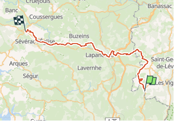

Length
52 km

Max alt
916 m

Uphill gradient
775 m
Km-Effort
63 km

Min alt
583 m

Downhill gradient
1048 m
Boucle
No
Creation date :
2025-03-07 20:24:35.64
Updated on :
2025-03-07 20:26:26.89
0m
Difficulty : Very easy

FREE GPS app for hiking
 SityTrail
IGN / Geographical institutes
SityTrail Plus
The world is yours!
About
Trail Moto cross of 52 km to be discovered at Occitania, Aveyron, Mostuéjouls. This trail is proposed by frank12.
Positioning
Country:
France
Region :
Occitania
Department/Province :
Aveyron
Municipality :
Mostuéjouls
Location:
Unknown
Start:(Dec)
Start:(UTM)
512739 ; 4900885 (31T) N.
Comments