Trail Other activity Villeneuve-sur-Aisne - Guignicourt (le tour 2) - Photo
 mick211
mick211

User

© OpenStreetMap contributors
Length
Length
8.3 km
Max alt
Max alt
84 m
Uphill gradient
Uphill gradient
64 m
Km-Effort
Km-Effort  
9.2 km
Min alt
Min alt
53 m
Downhill gradient
Downhill gradient
65 m
Boucle
Boucle
Yes
Creation date :
2015-06-25 00:00:00.0
Updated on :
2015-06-25 00:00:00.0

(0 Reviews)

Other activity
Other activity
2h00
Difficulty : Very easy

Scan this QR Code to open this trail in the SityTrail application

FREE GPS app for hiking

Logo SityTrail SityTrail

IGN / Geographical institutes

Download SityTrail from the App Store Download SityTrail from Google Play

Logo SityTrail SityTrail World

The world is yours!

Download SityTrail from the App Store Download SityTrail from Google Play Download SityTrail on Huawei AppGallery

About

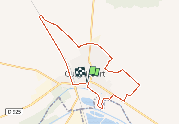
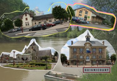
Trail Other activity of 8.3 km to be discovered at Hauts-de-France, Aisne, Villeneuve-sur-Aisne. This trail is proposed by mick211.

Description

Tour de Guignicourt retour par la voie ferrée.
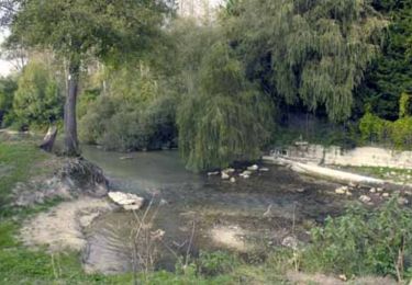
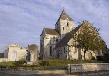
Départ place de la mairie. Prendre la rue de l'Ile St Louis devant l'église, au bord de l'Aisne longer la rivière par la gauche (vers l'amont) continuer passer près du camping,toujours suivre le bord de l'Aisne,un petit bois à votre gauche, au bout tourner à gauche pour remonter vers la route, la traverser et prendre le chemin (Promenade d'Illerieden)par la droite, à la station de pompage prendre le chemin à gauche (monte légèrement)à environ 150M tourner à droite puis 1er chemin à gauche ensuite idem, 1er chemin à gauche et encore 1er chemin à gauche.A la fourche, prendre à droite rue de Laon et 1er à droite rue de Cambrai,suivre la rue de Proviseux par le droite et 2eim à gauche (rue du Champ d'argent). Continuer jusqu'à la rue de Prouvais, la traverser pour suivre la rue Charles de Nazelle. Au bout de cette rue tourner à droite, suivre ce chemin jusqu'au pont du chemin de fer, passer dessous, tourner à gauche continuer jusqu'à la route D925, prendre à gauche et retour place de la mairie.

Elevation profile

Positioning

Country:
France
Region :
Hauts-de-France
Department/Province :
Aisne
Municipality :
Villeneuve-sur-Aisne
Location:
Unknown
Start:(UTM)
570040 ; 5476187 (31U) N.

Trails nearby

Trail Walking Berry-au-Bac - La Via Francigena -  Berry au Bac - Reims   - Photo
Walking
tracegps

Walking

Medium
(1)
Berry-au-Bac, Hauts-de-France, Aisne, France
28 km | 32 km-effort
5h 40min
No
Trail Walking Villeneuve-sur-Aisne - le tour de Guignicourt 2 - Photo
Walking
mick211

Walking

Very easy
Villeneuve-sur-Aisne, Hauts-de-France, Aisne, France
7.3 km | 8 km-effort
2h 30min
Yes
Trail Walking Berry-au-Bac - Saint-Rigobert - Photo
Walking
tracegps

Walking

Medium
(1)
Berry-au-Bac, Hauts-de-France, Aisne, France
7 km | 8 km-effort
1h 45min
Yes
Trail Walking Variscourt - Sainte-Geneviève - Photo
Walking
tracegps

Walking

Very difficult
(1)
Variscourt, Hauts-de-France, Aisne, France
15.6 km | 17.2 km-effort
3h 45min
Yes
Trail Walking Villeneuve-sur-Aisne - Le moulin Brûlé - Photo
Walking
tracegps

Walking

Medium
Villeneuve-sur-Aisne, Hauts-de-France, Aisne, France
11.8 km | 13.3 km-effort
3h 15min
Yes
Trail Walking Villeneuve-sur-Aisne - Guignicourt - La Ligne AR bois en vain 8.8 km - Photo
Walking
mick211

Walking

Medium
Villeneuve-sur-Aisne, Hauts-de-France, Aisne, France
8.6 km | 9.4 km-effort
2h 7min
Yes
Trail On foot Villeneuve-sur-Aisne - Guignicourt-Menneville - Photo
On foot
mick211

On foot

Very easy
Villeneuve-sur-Aisne, Hauts-de-France, Aisne, France
8.8 km | 9.5 km-effort
2h 0min
Yes
Trail Walking Berry-au-Bac - Berry au Bac - Merfy  - Photo
Walking
VANDERPUTTENMi

Walking

Very easy
Berry-au-Bac, Hauts-de-France, Aisne, France
21 km | 25 km-effort
5h 19min
No
Trail Walking Variscourt - Ste Geneviève par Variscourt  --> Pignicourt - Photo
Walking
mick211

Walking

Medium
Variscourt, Hauts-de-France, Aisne, France
9.2 km | 10 km-effort
2h 33min
Yes


Close
My subscriptions