


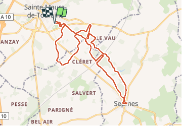
Sainte-Maure-de-Touraine - Sepmes via PRs - 20.5km 240m 4h35 (50mn) - 2025 03 19

Orcal37
User GUIDE

Length
20 km

Max alt
117 m

Uphill gradient
244 m
Km-Effort
24 km

Min alt
70 m

Downhill gradient
244 m
Boucle
Yes
Creation date :
2025-03-19 09:57:11.605
Updated on :
2025-03-23 08:57:51.117
4h35
Difficulty : Easy

FREE GPS app for hiking
 SityTrail
IGN / Geographical institutes
SityTrail Plus
The world is yours!
About
Trail Walking of 20 km to be discovered at Centre-Loire Valley, Indre-et-Loire, Sainte-Maure-de-Touraine. This trail is proposed by Orcal37.
Description
Sainte-Maure-de-Touraine - Sepmes via PRs - 20.5km 240m 4h35 (50mn) - 2025 03 19
Photos
 - 2025 03 19 - Photo 1")
 - 2025 03 19 - Photo 2")
 - 2025 03 19 - Photo 3")
 - 2025 03 19 - Photo 4")
 - 2025 03 19 - Photo 5")
 - 2025 03 19 - Photo 6")
 - 2025 03 19 - Photo 7")
 - 2025 03 19 - Photo 8")
 - 2025 03 19 - Photo 9")
 - 2025 03 19 - Photo 10")
 - 2025 03 19 - Photo 11")
 - 2025 03 19 - Photo 12")
 - 2025 03 19 - Photo 13")
 - 2025 03 19 - Photo 14")
 - 2025 03 19 - Photo 15")
Positioning
Country:
France
Region :
Centre-Loire Valley
Department/Province :
Indre-et-Loire
Municipality :
Sainte-Maure-de-Touraine
Location:
Unknown
Start:(Dec)
Start:(UTM)
319838 ; 5219561 (31T) N.
Comments